Edmondson Park railway station, Sydney
- Edmondson Park railway station, Sydney
Cityrail Station alt
station_name=Edmondson Park
servicearea=Airport & East Hills Line
servicearea_color=#East Hills line colour
servicearea_textcolor=white
servicearea2=South Line
servicearea_color2=#South line colour
servicearea_textcolor2=black
code=?
suburb=Edmondson Park
street=near Blaxland Rd
Railway Parade (future)
distance=?
altitude=?
traintype=Suburban limited stops
platforms=2
tracks=2
platform_arr=1 island
stationtype=Ground
gates=Yes
connect=Bus
disabled=Yes
facilities=N/A|
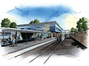
Edmondson Park railway station is a proposed station for the South West Rail Link to be located in the future town centre in the developing suburb of Edmondson Park and is expected to be opened in 2012. The proposed design includes an island platform, to be served by trains from the Airport & East Hills Line and some services from the South Line. The station is expected to be served by 4 trains per hour in the off-peak. [Transport Infrastructure Development Corporation, " [http://www.tidc.nsw.gov.au/GetDocument.aspx?PageID=987 "South West Rail Link: Environmental Assessment & Concept Plan"] ", Volume 1, Chapter 7: "Physical Description", pp. 2, 16. Accessed 12 May, 2007.]
Accessibility
The station will have Easy Access for wheelchairs.
Neighbouring stations
ee also
*South West Rail Link
References
External links
* [http://www.tidc.nsw.gov.au Transport Infrastructure Development Corporation]
----
Wikimedia Foundation.
2010.
Look at other dictionaries:
Beverly Hills railway station, Sydney — |servicearea textcolor=white|code=BVH|suburb=Beverly Hills|street=Morgan St|distance=14.65|altitude=?|traintype=Suburban all stops|platforms=2|tracks=2|platform arr=1 Island|stationtype=Ground|gates=No|connect=Bus|disabled=Yes facilities=… … Wikipedia
South West railway line, Sydney — Public transport infrastructure in Sydney logo= name=South West Rail Link transport mode=Commuter rail proposed line owner=Transport Infrastructure Development Corporation operation area=Leppington line length=12 km stations number=3 interchange… … Wikipedia
Airport and East Hills railway line, Sydney — Public transport infrastructure in Sydney logo= name=Airport East Hills Line transport mode=Commuter rail line line owner=CityRail operation area=City of Sydney City of Botany Bay City of Rockdale Marrickville Council City of Canterbury City of… … Wikipedia
Minto railway station — Minto … Wikipedia
Beverly Hills railway station — Beverly Hills … Wikipedia
Portsmouth — For other places with the same name, see Portsmouth (disambiguation). Portsmouth City and Unitary Authority Area City of Portsmouth … Wikipedia
Wagga Wagga, New South Wales — Infobox Australian Place type=city name=Wagga Wagga state=New South Wales caption=Looking down Baylis Street lga=City of Wagga Wagga county=Wynyard Clarendon stategov=Wagga Wagga fedgov=Riverina elevation=147 maxtemp = 22.0 mintemp = 9.0 rainfall … Wikipedia
Glenfield, New South Wales — Infobox Australian Place | type = suburb name = Glenfield city = Sydney state = nsw caption = Glefield railway station lga = City of Campbelltown postcode = 2167 pop = 6,800 (2006) est = 1881 area = propval = stategov = Macquarie Fields fedgov =… … Wikipedia
Moorebank, New South Wales — Moorebank Sydney, New South Wales Moorebank shopping centre Population … Wikipedia
Hurlstone Agricultural High School — Infobox School name = Hurlstone Agricultural High School imagesize = caption = location = streetaddress = region = city = Glenfield state = NSW district = province = county = postcode = postalcode = zipcode = country = Australia coordinates =… … Wikipedia