- Middelzee
-
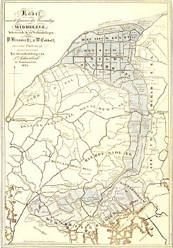 1834 map of the former Middelzee
The Middelzee (Dutch for "middle sea"; West Frisian: Middelsee), also called Bordine, was the estuary mouth of the River Boorn (West Frisian: Boarn) now in the Dutch province of Friesland. It ran from as far south as Sneek northward to the Wadden Sea and marked the border between main Frisian regions of Westergoa and Eastergoa. Other historical names for the Middelzee include Bordaa, Borndiep, Boerdiep, and Bordena.
Gradually the Middelzee silted up, forming the nije lannen ("new lands"). One village is called Nijlân, literally meaning "new land", and also there are several villages where the lands formerly of the Middelzee are still called it Nijlân. It can still be recognized as new land since there are only a small number of villages lying in the area of the former Middelzee. The fertile sea clay bottom is mostly used as meadow land but also Leeuwarden Air Base is situated on the new lands. The border between Eastergoa and Westergoa in the former Middlezee is now drained by the River Zwette (West Frisian: Swette), that runs from Sneek to Leeuwarden, but which once reached the southern edge of Het Bildt.
By the fifteenth century the Middelzee was reduced to a funnel shape along Frisia's north coast and further silting of the remaining part rendered it unusable. From the early sixteenth century the polder of Het Bildt was formed in that funnel, and is now a Frisian municipality that fills the mouth of what once was the Middelzee.
The name Middelzee is still used as a name for an administrative coalition between the so-called Middelzee municipalities of Het Bildt, Ferwerderadeel, Leeuwarderadeel, and Menaldumadeel.
References
- This text is based on an article on the West Frisian Wikipedia: fy:Middelsee.
Categories:

Wikimedia Foundation. 2010.