Laguna Miscanti

Laguna Miscanti
Laguna Miscanti Flag of Chile.svg
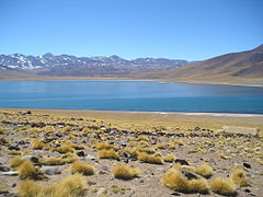
Laguna Miscanti with Cordón de Puntas Negras in the distance.
Location Antofagasta Region
Coordinates 23°44′S 67°47′W / 23.733°S 67.783°W / -23.733; -67.783Coordinates: 23°44′S 67°47′W / 23.733°S 67.783°W / -23.733; -67.783 [1]
Catchment area 303 km² [2]
Basin countries Chile
Surface area 13.4 km² [2]
Surface elevation 4,120 m [2]
References [1][2]

Laguna Miscanti is a brackish water lake located in the altiplano of the Antofagasta Region, in northern Chile. Miñiques volcano and Cerro Miscanti tower over this lake. This heart-shaped lake has a deep blue color. The western shoreline of the lake is separated by less than 1 km from the drainage divide between the lake and the Salar de Atacama basins.[2] Laguna Miscanti basin also has a common boundary with Salar de Talar basin.

A lava flow from an eruption of Miñiques separated Laguna Miscanti from Laguna Miñiques.[3]

The lake is part of one of the seven sectors of Los Flamencos National Reserve.

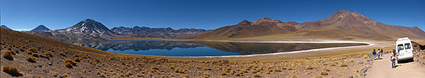
Panoramic View of Laguna Miscanti

Laguna miscanti panorama.jpg

References

  1. ^ a b Earth Info, earth-info.nga.mil webpage: [1]
  2. ^ a b c d e (Spanish) Geoquímica de aguas en cuencas cerradas: I, II y III Regiones - Chile Laguna Miscanti
  3. ^ "Miñiques". Global Volcanism Program, Smithsonian Institution. http://www.volcano.si.edu/world/volcano.cfm?vnum=1505-102. 


Wikimedia Foundation. 2010.

Игры ⚽ Поможем сделать НИР

Look at other dictionaries:

  • Laguna Miscanti — avec le Cordón de Puntas Negras en arrière plan. Administration …   Wikipédia en Français

  • Laguna Miscanti (Chile) — País  Chile Región Antofagasta Provincia Provincia de El Loa Superficie …   Wikipedia Español

  • Cerro Miscanti — Seen from the Laguna Miscanti, FLTR: Volcán Chiliques, Cerro Miscanti, Cordón Puntas Negras. Elevation …   Wikipedia

  • Lago Lejía (Chile) — Laguna Lejía País  Chile Región Región de Antof …   Wikipedia Español

  • Reserva Nacional Los Flamencos — Saltar a navegación, búsqueda Vista parcial de la Laguna Miscanti La Reserva Nacional los Flamencos fue creada en 1990 por la CONAF, posee 73.986 ha, se ubica en la comuna de San Pedro de Atacama, Región …   Wikipedia Español

  • Chiliques — The Chiliques volcano, seen from Laguna Miscanti …   Wikipedia

  • Cordón de Puntas Negras — Cordón Puntas Negras Cordón de Puntas Negras seen from Laguna Miscanti wit …   Wikipedia

  • Miñiques — Cerro Miñiques The Miñiques volcano, seen from the North …   Wikipedia

  • Chiliques — Vue du Chiliques depuis la Laguna Miscanti au sud. Géographie Altitude 5 778 m Massif Andes …   Wikipédia en Français

  • Chiliques (Chile) — Chiliques Volcán Chiliques visto desde la Laguna Miscanti Tipo Estratovolcán País …   Wikipedia Español

Share the article and excerpts

Direct link
Do a right-click on the link above
and select “Copy Link”