North Star Woolen Mill

North Star Woolen Mill
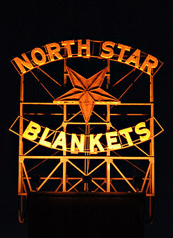
The North Star Blankets sign
Location: Minneapolis, Minnesota
Built: 1864
Architect: Unknown/ Pike & Cook/ C. F. Haglin & Sons[1]
Governing body: Private

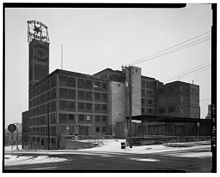
The North Star Woolen Mill is a building in downtown Minneapolis, Minnesota. The building, located in the St. Anthony Falls Historic District, was originally a textile mill for the North Star Woolen Company. The mill was built in 1864 by W.W. Eastman and Paris Gibson on the west side of the west side canal. High quality wool blankets, scarves, flannels, and yarns were manufactured at the facility and it became the nation's largest manufacturer of wool blankets by 1925.

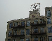
Back of the sign
North Star Woolen Mill

Entrepreneurs in the early days of Minneapolis had high hopes for developing a textile industry at the falls, similar to that of Lowell, Massachusetts. However, the industry never had as much success as hoped for, mainly because Minneapolis was a long distance from eastern markets and shipping centers. The North Star Woolen Mill was an exception, and it remained a significant industry in Minneapolis until the 1940s.[2]

In 1949 the North Star Woolen Company moved its operations to Lima, Ohio. The building sat empty for almost fifty years until it was re-developed in 1998-99 into lofts. The building maintains its existing exterior including a sign reading "North Star Blankets".

References

Notes

  1. ^ "National Register of Historic Places - National Register District Property Details". National Register of Historic Places. Minnesota Historical Society. 2007-04-25. http://nrhp.mnhs.org/DistrictPropDetails.cfm?DistrictID=5224. 
  2. ^ Pennefeather, Shannon M. (2003). Mill City: A Visual History of the Minneapolis Mill District. St. Paul, Minnesota: Minnesota Historical Society. 

Wikimedia Foundation. 2010.

Игры ⚽ Нужен реферат?

Look at other dictionaries:

  • List of contributing properties in the St. Anthony Falls Historic District — The following are the 85 contributing properties in the Saint Anthony Falls Historic District in Minneapolis, Minnesota, United States. About 56 still exist. The district s archaeological record is considered to be one of the most endangered… …   Wikipedia

  • Liste der Contributing Properties im Saint Anthony Falls Historic District — Saint Anthony Fälle Die Liste der Contributing Properties im Saint Anthony Falls Historic District nennt die 85 historischen Objekte, die zu diesem geschützten Gebiet in Minneapolis, Minnesota, gehören. Von dieser Liste sind 56 Objekte noch… …   Deutsch Wikipedia

  • Hennepin Island tunnel — was a convert|2500|ft|m|sing=on long underground passage in Saint Anthony, Minnesota (now Minneapolis) dug beneath the Mississippi River riverbed between 1868 and 1869 to create a downstream spillway for hydro plants, milling and lumber business… …   Wikipedia

  • History of Minneapolis, Minnesota — Minneapolis is the largest city in the state of Minnesota in the United States, and the county seat of Hennepin County. The origin and growth of the city was spurred by the proximity of Fort Snelling, the first major United States military… …   Wikipedia

  • List of Historic Mechanical Engineering Landmarks — The following is a list of Historic Mechanical Engineering Landmarks as designated by the American Society of Mechanical Engineers since it began the program in 1971. The designation is granted to existing artifacts or systems representing a… …   Wikipedia

  • List of National Historic Sites of Canada — This is a complete list of the National Historic Sites of Canada. All such designations are made by the federal Minister of the Environment on the advice of the Historic Sites and Monuments Board of Canada . As of March 2008, there are 935 sites …   Wikipedia

  • National Register of Historic Places listings in Humboldt County, California — Map of all coordinates from Google Map of all coordinates from Bing …   Wikipedia

  • Clinton, New Jersey — See also: Clinton Township, New Jersey Clinton   Town   Town of Clinton …   Wikipedia

  • Georgetown, Ontario — Georgetown is a community in the town of Halton Hills, Ontario, Canada. It is located approximately 60km west of Toronto, situated on the Credit River, and is part of the municipality of Halton Region. Georgetown is part of the Greater Toronto… …   Wikipedia

  • Merced River — Coordinates: 37°20′57″N 120°58′32″W / 37.34917°N 120.97556°W / 37.34917; 120.97556 …   Wikipedia

Share the article and excerpts

Direct link
Do a right-click on the link above
and select “Copy Link”