- Criação Velha
-
Criação Velha Civil Parish (Freguesia) 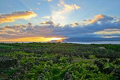 The vineyard landscape of Criação Velha replaced cattle and the dairy industry, due to the quality of the Verdelho Wines produced from the island
Official name: Freguesia de Criação Velha Name origin: criação velha, Portuguese compound word, literally old creation (criação means raising and velha means old) Country  Portugal
Autonomous Region  Azores
Group Central Island Pico Municipality Madalena Localities Alto da Cêrca, Canada de Beatriz, Canada de Pedro Nunes, Canada do Bacelo, Canada do Costa, Canada do Japão, Canada do Monte, João Lima, Lajidos, Rosário, Tapadas Center Criação Velha - elevation 76 m (249 ft) - coordinates 38°30′35″N 28°31′18″W / 38.50972°N 28.52167°W Highest point Pico Pequeno - location Ponta do Pico, Criação Velha, Madalena - elevation 2,351 m (7,713 ft) - coordinates 38°28′6″N 28°23′56″W / 38.46833°N 28.39889°W Lowest point Sea level - location Atlantic Ocean - elevation 0 m (0 ft) Length 11.45 km (7 mi), Northwest-Southeast Width 2.36 km (1 mi), Southwest-Northeast Area 16.43 km2 (6 sq mi) - land 14.03 km2 (5 sq mi) - urban 2.4 km2 (1 sq mi) Population 818 (2001) Density 49.79 / km2 (129 / sq mi) LAU Freguesia/Junta Freguesia - location Estrada Regional, Criação Velha, Madalena - elevation 23 m (75 ft) - coordinates 38°30′46″N 28°31′47″W / 38.51278°N 28.52972°W Timezone Azores (UTC-1) - summer (DST) Azores (UTC0) ISO 3166-2 code PT- Postal Zone 9950-232 Criação Velha Area Code & Prefix (+351) 292 XXX-XXXX Demonym Piquense Patron Saint Nossa Senhora das Dores Parish Address Estrada Regional
9950-232 Criação VelhaWikimedia Commons: Criação Velha Criação Velha is a civil parish in the municipality of Madalena on the island of Pico in the Azores. Census records for the community in 2001, found about 818 inhabitants in residence in the parish.
History
Historical evidence, from the municipality of Madalena, relates that the name Criação Velha comes from an agricultural reference: it was an area where cattle (no distinction) were raised long ago. The term criação means "raising", and Velha is old, referring to historical records that the area was (and continues to be) important in this pursuit. Owing to the rich fertile lands the early settlers occupied most of their time with agriculture and wine production, slowly developing a commerce sector and industry later into its existence.
The church of Nossa Senhora das Dores was constructed in the late part of the 18th Century.
Geography
The parish is located in the western coast of the municipality, sandwiched between the parishes of Madalena and Candelária; a pie-shaped wedge that extends just to the base of Ponte do Pico to an area of about 2.75 kilometers at its maximum width. Unlike the other parishes with the municipality of Madalena, Criação Velha's borders does not extend to the top of Pico (its limit stops about 2 kilometers from the summit of the stratovolcano). The area is relatively hilly, sloping gradually from forested parcels into an area of semi-cultivatable land and then scrub pasture-lands. Most practical farming occurs around the central parish, since the forested lands are dense and impractical. The area is recognized for a series of grottos, with about 5 kilometers of extensions, carved from the dykes and subterranean lava fields along the island's history.
Categories:- Parishes of Madalena (Azores)
- Azores geography stubs

Wikimedia Foundation. 2010.