- Motiti Island
-
Motiti Island Maori: Motiti 
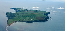
An aerial view of Motiti Island.Geography Location Bay of Plenty Coordinates 37°37′33″S 176°25′20″E / 37.6257°S 176.4221°E Area 10 km2 (4 sq mi) Highest elevation 57 m (187 ft) Country Demographics Population 27[1] (as of 2006) Motiti Island is located off the Bay of Plenty coast of New Zealand's North Island. It is 21 kilometres (13 mi) north-east of Tauranga and 9.4 kilometres (5.8 mi) north-east of Papamoa. There were 18 homes occupied by 27 people on the island in the 2006 Census.[1]
A relatively flat island covering some 10 km2 (3.9 sq mi), it is composed mainly of Miocene volcanic rocks, overlaid with more recent sediments in the south.[2] The principal activity on the island is agriculture, with a developing avocado plantation. Most residents and visitors travel to the island by air.
On 9 October, 2011, the 45' launch M/V Excalibur ran aground offshore in bad weather. The crew of six was resuced, but the ship was considered a total loss. [3]
In 2011 the MV Rena ran aground on Astrolabe Reef. Oil from the resulting spill, as well as shipping containers and their contents, reached the shoreline of the island.[4] Coordinates: 37°37′33″S 176°25′20″E / 37.6257°S 176.4221°E
See also
References
- ^ a b QuickStats About Motiti Island, 2006 Census, Statistics New Zealand. Retrieved 29 October 2010.
- ^ Motiti Island, An Encyclopaedia of New Zealand (1966). Retrieved 29 October 2010.
- ^ http://www.cargolaw.com/presentations_casualties.php
- ^ "Containers, oil to spill from 'dying' Rena". Stuff.co.nz (New Zealand). 2011-10-17. http://www.stuff.co.nz/environment/rena-crisis/5794354/Containers-oil-to-spill-from-dying-Rena. Retrieved 2011-10-20.
Categories:- Islands of New Zealand
- Bay of Plenty Region
Wikimedia Foundation. 2010.

