- Sapuyes
-
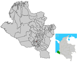
Sapuyes — Municipality and town — Location of the municipality and town of Sapuyes in the Nariño Department of Colombia. Country  Colombia
Department Nariño Department Time zone Colombia Standard Time (UTC-5) Sapuyes is a town and municipality in the Nariño Department, Colombia.
Municipalities in the Nariño Department Albán · Aldana · Ancuya · Arboleda · Barbacoas · Belén · Buesaco · Chachagüí · Colón (Génova) · Consaca · Contadero · Córdoba · Cuaspud · Cumbal · Cumbitara · El Charco · El Rosario · El Tablón · El Tambo · Francisco Pizarro · Funes · Guachucal · Guaitarilla · Gualmatán · Iles · Imues · Ipiales · La Cruz · La Florida · La Llanada · La Tola · La Unión · Leiva · Linares · Los Andes · Magui · Mallama · Mosquera · Nariño · Olaya Herrera · Ospina · Pasto (capital) · Policarpa · Potosí · Providencia · Puerres · Pupiales · Ricaurte · Roberto Payán · Samaniego · San Bernardo · Sandona · San Lorenzo · San Pablo · San Pedro de Cartago · Santa Barbara · Santacruz · Sapuyes · Taminango · Tangua · Tumaco · Tuquerres · Yacuanquer
Categories:- Populated places in the Nariño Department
- Municipalities of Nariño
- Nariño Department geography stubs
Wikimedia Foundation. 2010.

