- Sentinel Range
-
- This article is about the mountain range in Antarctica. For the range in the northern Canadian Rockies see Sentinel Range (Canada).
Sentinel Range Range  Location of Sentinel Range in Western Antarctica
Continent Antarctica Region Marie Byrd Land Part of Ellsworth Mountains Borders on Heritage Range Highest point Vinson Massif - elevation 4,892 m (16,050 ft) - coordinates 78°31′31.74″S 85°37′01.73″W / 78.5254833°S 85.6171472°W Length 185 km (115 mi), NNW-SSE Width 48 km (30 mi)  Sentinel Range, USGS Map.
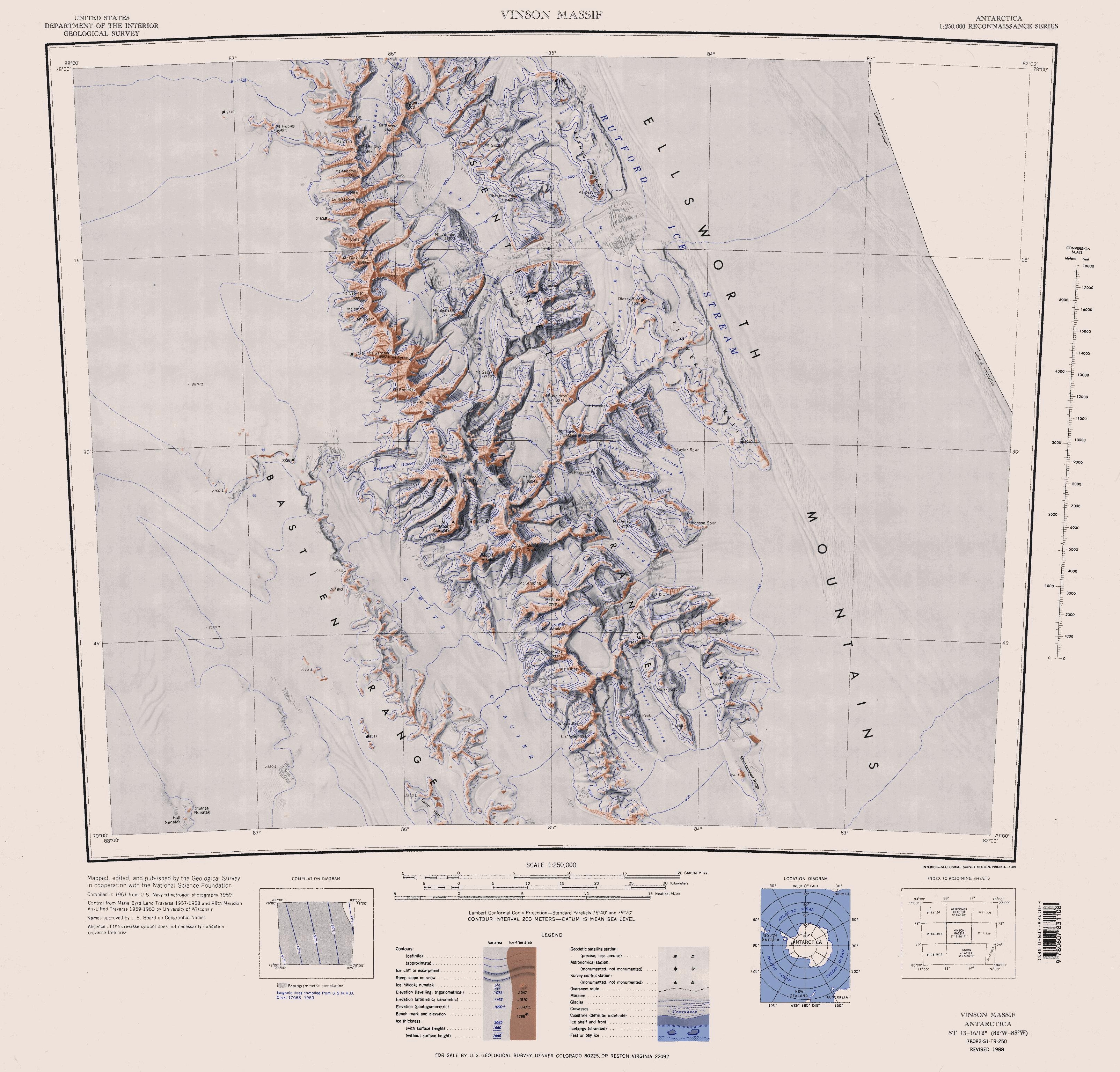
The Sentinel Range is a major mountain range situated northward of Minnesota Glacier and forming the northern half of the Ellsworth Mountains in Antarctica. The range trends NNW-SSE for about 185 km (115 mi) and is 24 to 48 km (15 to 30 mi) wide. Many peaks rise over 4,000 m (13,100 ft) and Vinson Massif (4892 m) in the southern part of the range is the highest elevation on the continent.[1]
The range was first sighted and photographed from the air on November 23, 1935, by Lincoln Ellsworth who in naming it recognised its prominent position as a landmark on an otherwise featureless ice surface. The range was first visited and partially surveyed in January 1958 by the Marie Byrd Land Traverse party, led by Charles R. Bentley. The entire range was mapped by USGS from aerial photography taken by U.S. Navy, 1958-61.[1] Coordinates: 78°10′S 85°30′W / 78.167°S 85.5°W
Mountains and peaks
Mount Alf
Mount Alf is a mountain rising over 3,200 m between Mount Sharp and Mount Dalrymple in the north part of the Sentinel Range. Mapped by the Marie Byrd Land Traverse party, 1957-58. Named by the Advisory Committee on Antarctic Names (US-ACAN) for Edward A. Alf, meteorologist, member of the 1957 wintering party at Byrd Station.[2]
Mount Atkinson
Mount Atkinson is a prominent mountain 3.5 miles (6 km) west-southwest of Mount Craddock. Mapped by United States Geological Survey (USGS) from surveys and U.S. Navy aerial photographs, 1957-60. Named by Advisory Committee on Antarctic Names (US-ACAN) after Richard C. Atkinson, Director, National Science Foundation, 1977-80.[3]
Mount Bentley
Mount Bentley is a mountain (4,245 m) standing 2 nautical miles (3.7 km; 2.3 mi) north of Mount Anderson in the main western ridge of the Sentinel Range. Discovered by the Marie Byrd Land Traverse party, 1957-58, and named for Dr. Charles R. Bentley, leader of the traverse party and chief traverse seismologist at Byrd Station, 1957-59.[4]
Mount Dalrymple
Mount Dalrymple is a mountain between Mount Alf and Mount Goldthwait in the northern part of the Sentinel Range. It was mapped by the Marie Byrd Land Traverse party, 1957–58 and named by the Advisory Committee on Antarctic Names for Paul C. Dalrymple, meteorologist, member of the wintering party at Little America V in 1957 and the South Pole Station in 1958. [5]
Mount Davis
Mount Davis is a mountain located 1.6 km north of Mount Bentley and 2.4 km southeast of Mount Hale. Discovered by the Marie Byrd Land Traverse party, 1957–58, and named for Leo E. Davis, geomagnetician and seismologist at Byrd Station in 1957.[6]
Mount Dawson
Mount Dawson is a sharp, pyramidal mountain located 4 km (2.5 mi) northwest of Mount Reimer. Discovered by the Marie Byrd Land Traverse Party, 1957–58, and named after Major Merle R. Dawson (d.1986), USA, leader of the Army-Navy Trail Party which established an oversnow route from Little America V to the site of Byrd Station in November–December 1956; Project Manager for Ship Operations in the Office of Polar Programs, National Science Foundation (NSF), 1965-70.[7]
Mount Giovinetto
Mount Giovinetto is the summit of a buttress-type mountain (4,090 m) located 2 nautical miles (3.7 km) north of Mount Ostenso in the main ridge of the Sentinel Range. Discovered by the Marie Byrd Land Traverse party, 1957-58, and named for Mario B. Giovinetto, glaciologist at Byrd Station in 1957.[8]
Mount Goldthwait
Mount Goldthwait is a prominent mountain (3,815 m) located 2.5 nautical miles (4.6 km) south of Mount Dalrymple. Discovered by the Marie Byrd Land Traverse Party, 1957-58, and named for Richard P. Goldthwait, consultant, Technical Panel on Glaciology, U.S. National Committee for the IGY, and later Director, Institute of Polar Studies, Ohio State University.[9]
Mount Hale
Mount Hale is a mountain (3,595 m) standing 1.5 mi NW of Mount Davis in the main ridge of the Sentinel Range. Discovered by the Marie Byrd Land Traverse party, 1957-58, under C.R. Bentley, and named for Daniel P. Hale, auroral physicist at Byrd Station and member of the traverse party.[10]
Mount Inderbitzen
Mount Inderbitzen is a mountain rising to over 2,600 m, located 12 miles (19 km) south-southeast of Mount Craddock and 1.5 miles (2.4 km) south of Mount Milton in the south part of the Sentinel Range. First mapped by USGS from surveys and U.S. Navy aerial photographs, 1957-59. Named by Advisory Committee on Antarctic Names (US-ACAN) in 1994 after Anton L. Inderbitzen, Associate Chief Scientist, Division of Polar Programs, National Science Foundation (NSF), 1983–86; Head, Antarctic Staff, NSF, 1986–91; Deputy Assistant Director for Research, USGS, from 1991. At NSF, Inderbitzen was responsible for the coordination and planning of all scientific activities within the United States Antarctic Program (USAP), and for the formulation and enforcement of U.S. environmental regulations in Antarctica.[11]
Mount Levack
Mount Levack is a mountain located 21 km (13 mi) east of Mount Ostenso in the central part of the Sentinel Range. First mapped by USGS from surveys and U.S. Navy air photos, 1957-59. Named by US-ACAN for Major Herbert T. Levack, United States Air Force (USAF), who participated in establishing the South Pole Station in the 1956-57 season.[12]
Mount Milton
Mount Milton is a mountain (3,000 m) located 11 mi SSE of Mount Craddock and 1.5 mi SE of Mount Southwick, in the southern part of the Sentinel Range. First mapped by USGS from surveys and U.S. Navy (USN) air photos, 1957-59. Named by US-ACAN for Patrick G. Milton, aviation machinist's mate, USN, who served as plane captain on a reconnaissance flight to these mountains on Jan. 28, 1958.[13]
Mount Ostenso
Mount Ostenso is a mountain (4,180 m) 2 nautical miles (3.7 km) south of Mount Giovinetto in the main ridge of the Sentinel Range. First mapped by the Marie Byrd Land Traverse Party (1957-58) led by C.R. Bentley, and named for Ned A. Ostenso, traverse seismologist at Byrd Station (1957) and a member of the party.[14]
Mount Reimer
Mount Reimer is a mountain, 2,430 m, in the northern portion of the Sentinel Range, standing on the south side of Newcomer Glacier 5 mi SW of Mount Warren. Named by US-ACAN for John D. Reimer of U.S. Navy Squadron VX-6, aerial photographer on flights over this range on Dec. 14-15, 1959.[15]
Mount Schmid
Mount Schmid is a mountain on the south side of Embree Glacier, rising 8 km east of Mount Goldthwait. Mapped by USGS from surveys and US Navy air photos, 1957-59. Named by the US-ACAN for Captain Ernest A. Schmid, USAF, who participated in the establishment of the IGY South Pole Station during the 1956-57 season.[16]
Mount Segers
Mount Segers is a mountain on a ridge at the east side of the head of Crosswell Glacier, 11 km (7 mi) east of Mount Tyree, in the central part of the Sentinel Range. Discovered by US Navy Squadron VX-6 on photographic flights of Dec. 14-15, 1959, and mapped by USGS from these photos. Named by US-ACAN for Chester W. Segers, a Navy cook and a member of the first wintering party at the South Pole Station during the IGY in 1957.[17]
Mount Ulmer
Mount Ulmer is a prominent peak situated 2 miles north of Mount Washburn in the northern part of the Sentinel Range. It was discovered in his trans-Antarctic flight on November 23, 1935, by Lincoln Ellsworth who called it "Mount Mary Louise Ulmer", after his wife. The peak was reidentified by comparing Ellsworth's photograph with those taken in 1959 by the U.S. Navy.[18]
Mount Wyatt Earp
Mount Wyatt Earp is a mainly snow-covered peak, 2,370 m, standing 3 nautical miles (6 km) west-northwest of Mount Ulmer in the north part of the range. Discovered by Lincoln Ellsworth on his trans-Antarctic flight of November 23, 1935. Named by the US-ACAN for the ship Wyatt Earp, used by Ellsworth in four expeditions to Antarctica between 1933 and 1939.[19]
References
- ^ a b "Sentinel Range". Geographic Names Information System, U.S. Geological Survey. http://geonames.usgs.gov/pls/gnispublic/f?p=gnispq:5:::NO::P5_ANTAR_ID:13574. Retrieved 2004-11-03.
- ^ "Mount Alf". Geographic Names Information System, U.S. Geological Survey. http://geonames.usgs.gov/pls/gnispublic/f?p=gnispq:5:::NO::P5_ANTAR_ID:253. Retrieved 2010-11-11.
- ^ "Mount Atkinson". Geographic Names Information System, U.S. Geological Survey. http://geonames.usgs.gov/pls/gnispublic/f?p=gnispq:5:::NO::P5_ANTAR_ID:696. Retrieved 2008-03-22.
- ^ "Mount Bentley". Geographic Names Information System, U.S. Geological Survey. http://geonames.usgs.gov/pls/gnispublic/f?p=gnispq:5:::NO::P5_ANTAR_ID:1250. Retrieved 2010-11-11.
- ^ "Mount Dalrymple". Geographic Names Information System, U.S. Geological Survey. http://geonames.usgs.gov/pls/gnispublic/f?p=gnispq:5:::NO::P5_ANTAR_ID:3476. Retrieved 2006-09-07.
- ^ "Mount Davis". Geographic Names Information System, U.S. Geological Survey. http://geonames.usgs.gov/pls/gnispublic/f?p=gnispq:5:::NO::P5_ANTAR_ID:3573. Retrieved 2006-10-09.
- ^ "Mount Dawson". Geographic Names Information System, U.S. Geological Survey. http://geonames.usgs.gov/pls/gnispublic/f?p=gnispq:5:::NO::P5_ANTAR_ID:3599. Retrieved 2005-11-05.
- ^ "Mount Giovinetto". Geographic Names Information System, U.S. Geological Survey. http://geonames.usgs.gov/pls/gnispublic/f?p=gnispq:5:::NO::P5_ANTAR_ID:5700. Retrieved 2010-11-11.
- ^ "Mount Goldthwait". Geographic Names Information System, U.S. Geological Survey. http://geonames.usgs.gov/pls/gnispublic/f?p=gnispq:5:::NO::P5_ANTAR_ID:5808. Retrieved 2010-11-11.
- ^ "Mount Hale". Geographic Names Information System, U.S. Geological Survey. http://geonames.usgs.gov/pls/gnispublic/f?p=gnispq:5:::NO::P5_ANTAR_ID:6223. Retrieved 2010-11-11.
- ^ "Mount Inderbitzen". Geographic Names Information System, U.S. Geological Survey. http://geonames.usgs.gov/pls/gnispublic/f?p=gnispq:5:::NO::P5_ANTAR_ID:7281. Retrieved 2008-03-20.
- ^ "Mount Levack". Geographic Names Information System, U.S. Geological Survey. http://geonames.usgs.gov/pls/gnispublic/f?p=gnispq:5:::NO::P5_ANTAR_ID:8756. Retrieved 2005-11-05.
- ^ "Mount Milton". Geographic Names Information System, U.S. Geological Survey. http://geonames.usgs.gov/pls/gnispublic/f?p=gnispq:5:::NO::P5_ANTAR_ID:10019. Retrieved 2010-11-11.
- ^ "Mount Ostenso". Geographic Names Information System, U.S. Geological Survey. http://geonames.usgs.gov/pls/gnispublic/f?p=gnispq:5:::NO::P5_ANTAR_ID:11192. Retrieved 2010-11-11.
- ^ "Mount Reimer". Geographic Names Information System, U.S. Geological Survey. http://geonames.usgs.gov/pls/gnispublic/f?p=gnispq:5:::NO::P5_ANTAR_ID:12496. Retrieved 2010-11-11.
- ^ "Mount Schmid". Geographic Names Information System, U.S. Geological Survey. http://geonames.usgs.gov/pls/gnispublic/f?p=gnispq:5:::NO::P5_ANTAR_ID:13385. Retrieved 2005-10-02.
- ^ "Mount Segers". Geographic Names Information System, U.S. Geological Survey. http://geonames.usgs.gov/pls/gnispublic/f?p=gnispq:5:::NO::P5_ANTAR_ID:13534. Retrieved 2005-10-02.
- ^ "Mount Ulmer". Geographic Names Information System, U.S. Geological Survey. http://geonames.usgs.gov/pls/gnispublic/f?p=gnispq:5:::NO::P5_ANTAR_ID:15760. Retrieved 2005-09-30.
- ^ "Mount Wyatt Earp". Geographic Names Information System, U.S. Geological Survey. http://geonames.usgs.gov/pls/gnispublic/f?p=gnispq:5:::NO::P5_ANTAR_ID:16829. Retrieved 2010-11-11.
 This article incorporates public domain material from websites or documents of the United States Geological Survey.Categories:
- Ellsworth Mountains
- Mountain ranges of Marie Byrd Land

Wikimedia Foundation. 2010.