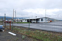
- Grant County Regional Airport
-
Grant County Regional Airport
Ogilvie FieldIATA: JDA – ICAO: KGCD Summary Airport type Public Operator Grant County Location John Day, Oregon Elevation AMSL 3,697 ft / 1,126.8 m Coordinates 44°24′15″N 118°57′45″W / 44.40417°N 118.9625°WCoordinates: 44°24′15″N 118°57′45″W / 44.40417°N 118.9625°W Website Runways Direction Length Surface ft m 17/35 4,500 1,372 Asphalt 9/27 3,443 1,049 Asphalt Grant County Regional Airport (IATA: JDA, ICAO: KGCD), is a public airport located one mile (1.6 km) southwest of John Day in Grant County, Oregon, USA. Grant County Airport previously carried the FAA identifier 5J0.
External links
- Grant County Services
- Resources for this airport:
- AirNav airport information for KGCD
- ASN accident history for GCD
- FlightAware airport information and live flight tracker
- NOAA/NWS latest weather observations
- SkyVector aeronautical chart for KGCD
- FAA current GCD delay information
Categories:- Airports in Grant County, Oregon
- Oregon airport stubs
- Oregon building and structure stubs
Wikimedia Foundation. 2010.

