- Chiautempan, Tlaxcala
-
Chiautempan Mural depicting the foundation of Chiautempan

Seal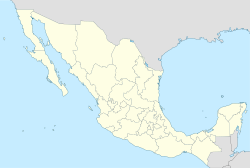
 Chiautempan
Coordinates: 19°19′00″N 98°11′00″W / 19.3166667°N 98.1833333°W Country  Mexico
State Tlaxcala Municipality Santa Ana Chiautempan Founded 1380 AD Government - Presidente Municipal Linda Marina Dolores Munive Temoltzín (2005-08) Area(municip.) - Total 66.21 km2 (25.6 sq mi) Elevation 2,300 m (7,546 ft) Population (2005) - Total 46,776 (municip.) Time zone CST (UTC-6) Postal code 90800 Area code(s) 246 Demonym Chiautempense Website www.chiautempan.gob.mx Chiautempan (also: Santa Ana Chiautempan) is a city and its surrounding municipality of the same name located in the south-central part of the Mexican state of Tlaxcala. The city serves as the municipal seat of the municipality, which covers an area of 66.21 km² (25.56 sq mi). At the 2005 census it had a population of 46,776 inhabitants, the fourth-largest community in the state in population (after Villa Vicente Guerrero, Apizaco, and Huamantla). The city lies at the extreme western end of the municipality, which had a census population of 63,300 inhabitants.
Its largest other communities are the towns of San Bartolomé Cuahuixmatlac, San Pedro Tlalcuapan de Nicolás Bravo, and San Pedro Muñoztla.
References
- Link to tables of population data from Census of 2005 INEGI: Instituto Nacional de Estadística, Geografía e Informática
- Chiautempan (Enciclopedia de los Municipios de México)
External links
- Ayuntamiento Chiautempan Official website
Categories:- Populated places in Tlaxcala
- Municipalities of Tlaxcala
- Tlaxcala geography stubs


Wikimedia Foundation. 2010.