- Lake Manzala
-
Lake Manzala 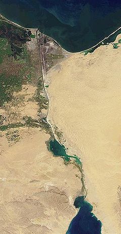
The Suez Canal in 2001, with Lake Manzala near the northern outlet partially drained and converted to farmland. Coordinates 31°16′N 32°12′E / 31.267°N 32.2°ECoordinates: 31°16′N 32°12′E / 31.267°N 32.2°E Lake type brackish Basin countries Egypt Lake Manzala (also Manzaleh) is a brackish lake, sometimes called a lagoon, in northeastern Egypt on the Nile Delta near Port Said and a few miles from the ancient ruins at Tanis.[1][2] It is the largest of the northern deltaic lakes of Egypt.[3] As of 2008 it is 47km long and 30km wide.[3]
Contents
Geography
Lake Manzala is long but quite shallow. Though Lake Manzala's unaltered depth is only four to five feet, alterations to the depth were made during the construction of the Suez Canal to allow the Canal to extend 29 miles lengthwise along the lake.[4] Its bed is soft clay.[4] Before construction of the Suez Canal, Lake Manzala was separated from the Mediterranean Sea by a strip of sand 200 to 300 yards wide.
Port Said was established adjacent to Lake Manzala during the nineteenth century to support canal construction and related travel.[5] The lake's location directly south of the Port Said Airport restricts the city's capacity for urban growth.[5]
Suez Canal
Lake Manzala is the northern-most of three natural lakes intersected by the Suez Canal, the other two being Lake Timsah and the Great Bitter Lake. Construction of the canal proceeded from north to south, reaching Manzala first. Due to the lake's shallowness, it was necessary to dig a banked channel for ships to pass.
Ecology
Lake Manzala served as a significant source of inexpensive fish for human consumption in Egypt, but pollution and lake drainage have reduced the lake's productivity. In 1985, the lakes fishery was an open area of 89,000 ha and employed roughly 17,000 workers.[1] The government of Egypt drained substantial portions of the lake in an effort to convert its rich Nile deposits to farmland. The project was unprofitable: crops did not grow well in the salty soil and the value of resulting produce was less than the market value of the fish that the reclaimed land had formerly yielded. By 2001, Lake Manzala had lost approximately 80 percent of its former area through the effects of drainage efforts.[6]
Notes
- ^ a b Dinar, p.51
- ^ Margaret S. Drower (1995). Flinders Petrie: a life in archaeology (Second edition). ASCE Publications. pp. 72. ISBN 9780299146245. http://books.google.com/?id=7TCLb4DJRLwC&pg=PA72&dq=Lake+Manzala+Suez+Canal. Retrieved 2009-04-10.
- ^ a b Zahran, p.283
- ^ a b Jerry R. Rogers, Glenn Owen (2004). Water Resources and Environmental History. ASCE Publications. pp. 124. ISBN 9780784407387. http://books.google.com/?id=jFGHnqSKENIC&pg=PA124&dq=Lake+Timsah. Retrieved 2009-04-10.
- ^ a b John Melady (2206). Pearson's prize: Canada and the Suez Crisispublisher= Dundurn Press Ltd.. pp. 116. ISBN 9781550026115. http://books.google.com/?id=YwSR4FsUOdMC&pg=PA116&dq=Lake+Manzala+Suez+Canal. Retrieved 2009-04-10.
- ^ Ibrahim, p.145
References
- Dinar, Ariel (1995). Restoring and protecting the world's lakes and reservoirs. World Bank Publications. ISBN 0821333216.
- Ibrahim, Barbara (2003). Egypt: an economic geography. I.B.Tauris. ISBN 1860645488.
- Penn, James R. (2001). Rivers of the world. ABC-CLIO. ISBN 1576070425.
- Zahran, M.A. (2008). The Vegetation of Egypt. Springer. ISBN 1402087551.
Categories:- Lakes of Egypt
- Nile River Delta
- Port Said

Wikimedia Foundation. 2010.