- Te Whakatōhea
Infobox Iwi
iwi_name =Te Whakatōhea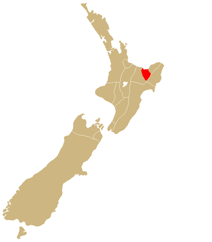
iwi_location =Bay of Plenty
waka =Arautauta ,Mataatua
population =9,948
united_tribes_no. =52
url =Te Whakatōhea are a
Māori iwi located in the easternBay of Plenty region ofNew Zealand . The iwi comprises six hapu: "Ngāi Tamahaua", "Ngāti Ira", "Ngāti Ngahere", "Ngāti Patumoana", "Ngāti Ruatakena" and "Te Ūpokorehe". In the 2006 Census, 12,072 people claimed an affiliation with Te Whakatōhea. [cite web|title=2006 Census – QuickStats About Māori (revised)|url=http://www.stats.govt.nz/census/2006-census-data/quickstats-about-maori/2006-census-quickstats-about-maori-revised.htm?page=para009Master|publisher=Statistics New Zealand|date=2007-04-04|accessdate=2007-05-25]The iwi is traditionally centred in the area around the town of
Opotiki . The traditional territorial lands extend eastwards from Ohiwa Harbour to Opape along the coastline, and inland to Matawai. These lands have long held an abundance of food resources, particularly seafood. Most of themarae of the iwi are located near the coast, historically to defend its marine resources.History
Te Whakatōhea can trace their history to the arrival of Māori settlers on the "
Nukutere " and "Mataatua " canoes. Te Whakatōhea are the descendants of Tutamure and Hine-i-kauia. Tūtāmure was a descendant of the "Nukutere" settlers, and was the leader of the Panenehu tribe. Hine-i-kauia was a descendant of the "Mataatua" settlers, who arrived in New Zealand nine generations after the "Nukutere" settlers. Tūtāmure and Hine-i-kauia were married, and their descendants would eventually form the iwi Te Whakatōhea.For centuries, Te Whakatōhea fought many battles with their neighbours, including
Ngāi Tai in the east, andNgāti Awa andNgāi Tūhoe in the west. The iwi initially had good relations with European settlers and Christian missionaries. However, in 1865, following the murder of German missionaryCarl Völkner , and with increasing demands from European settlers for more land, Crown soldiers invaded Te Whakatōhea land. Almost 600 km² of Te Whakatōhea land was confiscated by the Crown under the "New Zealand Settlements Act of 1863".The twentieth century saw an increasing government recognition that Te Whakatōhea had suffered grievances at the hands of the Crown. In 1996, the New Zealand government signed a Deed of Settlement, acknowledging and apologising for the invasion and confiscation of Te Whakatōhea lands, and the subsequent economic, cultural and developmental devastation suffered by the iwi. Te Whakatōhea are presently preparing to negotiate a full settlement with the New Zealand government.
Governance
The Te Whakatōhea Māori Trust Board, established in 1952, administers the assets of the iwi, and provides education and health services, along with training in various commercial fields, to members. The Trust Board will also negotiate a final settlement between Te Whakatōhea and the New Zealand government.
ee also
*
List of Māori iwi Notes
References
*cite web | author = Walker, Ranginui | title = Te Whakatōhea | url = http://www.TeAra.govt.nz/NewZealanders/MaoriNewZealanders/TeWhakatohea/en | publisher = Te Ara – the Encyclopedia of New Zealand | date = 2006-09-26 | accessdate = 2007-04-02
*cite web | url = http://www.whakatohea.co.nz | title = Te Whakatōhea Māori Trust Board website | accessdate = 2007-04-02
Wikimedia Foundation. 2010.