- Independence Rock (Wyoming)
Infobox nrhp
name = Independence Rock
nrhp_type = nhl
caption = Independence Rock
location = 60 mi. SW of Casper onWYO 220
nearest_city =
lat_degrees =
lat_minutes =
lat_seconds =
lat_direction =
long_degrees =
long_minutes =
long_seconds =
long_direction =
area =
built =
architect =
architecture =
designated =January 20 ,1961
added =October 15 ,1966
visitation_num =
visitation_year =
refnum = 66000757
mpsub =
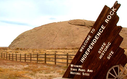
governing_body = Wyoming State ParksIndependence Rock is a large
granite rock, approximately 120 feet (36 m) high, in southwestern Natrona County,Wyoming , along Wyoming Highway 220. During the middle of the 19th century, the rock was a prominent and well-known landmark on theOregon Trail andMormon Trail . It was designated aNational Historic Landmark in 1961. It is now part of Independence Rock State Historic Site, owned and operated by the state of Wyoming.Description
The rock is a large rounded extrusion of
Archean granite typical of the surrounding region. Its appearance is somewhat like the roundedEnchanted Rock ofTexas or theUluru inAustralia (also called Ayer's Rock) , although smaller in size. It is located in the highplateau region of central Wyoming, north of the Green Mountains and close to the Sweetwater River. It is accessible from a rest area onWyoming Highway 220 , approximately 20 miles (32 km) northeast of Muddy Gap. There have been several theories regarding how the rock was carved.History
The rock derives its name from the fact that it lies directly along the route of the
Emigrant Trail and that emigrant wagon parties bound forOregon orCalifornia , which usually left theMissouri River in the early spring, attempted to reach the rock byJuly 4 (Independence Day in theUnited States ), in order to reach their destinations before the first mountain snowfalls.During the period of westward emigration on the trail (from 1843 to 1869), it was common for emigrants to carve their names in the granite rock, especially near the summit. Other emigrants left behind messages, sometimes for parties behind them on the trail, in axle grease. Many instances of such carved
graffiti are visible today at the summit of the rock, which is accessible by an easy free climb up the surface of the rock.The rock is located near several other important landmarks on the Trails, including Devil's Gate and
Martin's Cove . An LDS-run museum is located near these sites and is open year-round.Gallery
Wikimedia Foundation. 2010.