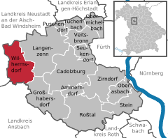
- Wilhermsdorf
-
Wilhermsdorf 
Coordinates 49°29′11″N 10°43′5″E / 49.48639°N 10.71806°ECoordinates: 49°29′11″N 10°43′5″E / 49.48639°N 10.71806°E Administration Country Germany State Bavaria Admin. region Middle Franconia District Fürth Local subdivisions 10 Ortsteile Mayor Harry Scheuenstuhl (SPD) Basic statistics Area 26.64 km2 (10.29 sq mi) Elevation 322 m (1056 ft) Population 5,081 (31 December 2010)[1] - Density 191 /km2 (494 /sq mi) Other information Time zone CET/CEST (UTC+1/+2) Licence plate FÜ Postal code 91452 Area code 09102 Website www.markt-wilhermsdorf.de Wilhermsdorf is a municipality in the district of Fürth in Bavaria in Germany. As of 2006 it has a population of 5,073. It is twinned with Feld am See in Austria and Jahnsdorf, also in Germany.
Neighboring municipalities
Wilhermsdorf borders
Towns and municipalities in Fürth Ammerndorf | Cadolzburg | Großhabersdorf | Langenzenn | Oberasbach | Obermichelbach | Puschendorf | Roßtal | Seukendorf | Stein | Tuchenbach | Veitsbronn | Wilhermsdorf | ZirndorfReferences
- ^ "Fortschreibung des Bevölkerungsstandes" (in German). Bayerisches Landesamt für Statistik und Datenverarbeitung. 31 December 2010. https://www.statistikdaten.bayern.de/genesis/online?language=de&sequenz=tabelleErgebnis&selectionname=12411-009r&sachmerkmal=QUASTI&sachschluessel=SQUART04&startjahr=2010&endjahr=2010.
Categories:- Municipalities in Bavaria
- Fürth district
- Middle Franconia geography stubs
Wikimedia Foundation. 2010.


