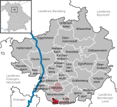
- Dormitz
-
Dormitz 
Coordinates 49°36′N 11°07′E / 49.6°N 11.11667°ECoordinates: 49°36′N 11°07′E / 49.6°N 11.11667°E Administration Country Germany State Bavaria Admin. region Upper Franconia District Forchheim Municipal assoc. Dormitz Mayor Gerhard Schmitt Basic statistics Area 4.58 km2 (1.77 sq mi) Elevation 305 m (1001 ft) Population 2,002 (31 December 2010)[1] - Density 437 /km2 (1,132 /sq mi) Other information Time zone CET/CEST (UTC+1/+2) Licence plate FO Postal code 91077 Area code 09134 Website www.dormitz.de Dormitz is a Bavarian municipality in the district of Forchheim (Upper Franconia), and the administrative headquarters of the Dormitz community, which includes the parishes of Kleinsendelbach and Hetzles.
History
Dormitz was first mentioned in 1142 and 1146 in two documents.
Dormitz | Ebermannstadt | Effeltrich | Eggolsheim | Egloffstein | Forchheim | Gößweinstein | Gräfenberg | Hallerndorf | Hausen | Heroldsbach | Hetzles | Hiltpoltstein | Igensdorf | Kirchehrenbach | Kleinsendelbach | Kunreuth | Langensendelbach | Leutenbach | Neunkirchen am Brand | Obertrubach | Pinzberg | Poxdorf | Pretzfeld | Unterleinleiter | Weilersbach | Weißenohe | Wiesenthau | WiesenttalReferences
- ^ "Fortschreibung des Bevölkerungsstandes" (in German). Bayerisches Landesamt für Statistik und Datenverarbeitung. 31 December 2010. https://www.statistikdaten.bayern.de/genesis/online?language=de&sequenz=tabelleErgebnis&selectionname=12411-009r&sachmerkmal=QUASTI&sachschluessel=SQUART04&startjahr=2010&endjahr=2010.
Categories:- Municipalities in Bavaria
- Forchheim district
- Upper Franconia geography stubs
Wikimedia Foundation. 2010.


