- Mistelgau
-
Mistelgau 

 MistelgauLocation of Mistelgau within Bayreuth district
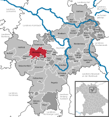
Coordinates 49°55′N 11°28′E / 49.91667°N 11.46667°ECoordinates: 49°55′N 11°28′E / 49.91667°N 11.46667°E Administration Country Germany State Bavaria Admin. region Upper Franconia District Bayreuth Municipal assoc. Mistelgau Local subdivisions 23 Ortsteile Mayor Georg Birner Basic statistics Area 39.43 km2 (15.22 sq mi) Elevation 435 m (1427 ft) Population 3,837 (31 December 2010)[1] - Density 97 /km2 (252 /sq mi) Other information Time zone CET/CEST (UTC+1/+2) Licence plate BT Postal code 95490 Area code 09279 Website www.mistelgau.de Mistelgau is a municipality in the district of Bayreuth in Bavaria in Germany.
Ahorntal | Aufseß | Bad Berneck | Betzenstein | Bindlach | Bischofsgrün | Creußen | Eckersdorf | Emtmannsberg | Fichtelberg | Gefrees | Gesees | Glashütten | Goldkronach | Haag | Heinersreuth | Hollfeld | Hummeltal | Kirchenpingarten | Mehlmeisel | Mistelbach | Mistelgau | Pegnitz | Plankenfels | Plech | Pottenstein | Prebitz | Schnabelwaid | Seybothenreuth | Speichersdorf | Waischenfeld | Warmensteinach | Weidenberg
References
- ^ "Fortschreibung des Bevölkerungsstandes" (in German). Bayerisches Landesamt für Statistik und Datenverarbeitung. 31 December 2010. https://www.statistikdaten.bayern.de/genesis/online?language=de&sequenz=tabelleErgebnis&selectionname=12411-009r&sachmerkmal=QUASTI&sachschluessel=SQUART04&startjahr=2010&endjahr=2010.
Categories:- Municipalities in Bavaria
- Bayreuth district
- Upper Franconia geography stubs


Wikimedia Foundation. 2010.