- Deizisau
-
Deizisau 

 DeizisauLocation of Deizisau within Esslingen district
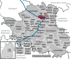

Coordinates 48°42′48″N 9°23′21″E / 48.71333°N 9.38917°ECoordinates: 48°42′48″N 9°23′21″E / 48.71333°N 9.38917°E Administration Country Germany State Baden-Württemberg Admin. region Stuttgart District Esslingen Mayor Thomas Matrohs Basic statistics Area 5.17 km2 (2.00 sq mi) Elevation 270 m (886 ft) Population 6,420 (31 December 2010)[1] - Density 1,242 /km2 (3,216 /sq mi) Other information Time zone CET/CEST (UTC+1/+2) Licence plate ES Postal code 73779 Area code 07153 Website www.deizisau.de Deizisau is a town in the district of Esslingen in Baden-Württemberg in southern Germany. Deizisau is located in between the towns of Plochingen and Esslingen. The river Neckar is flowing through this town.
Contents
Transportation
Deizisau is connected to the Bundesstrasse 10 which is a motorway. The S-Bahn Stuttgart has the stops Altbach and Plochingen in the vicinity.
Economy
Coca-Cola has a factory in Deizisau.[2]
References
- ^ "Bevölkerung und Erwerbstätigkeit" (in German). Statistisches Landesamt Baden-Württemberg. 31 December 2009. http://www.statistik-bw.de/Veroeffentl/Statistische_Berichte/3126_10001.pdf.
- ^ Coca-Cola Erfrischungsgetränke AG
- This article incorporates information from the German Wikipedia.
External links
Aichtal | Aichwald | Altbach | Altdorf | Altenriet | Baltmannsweiler | Bempflingen | Beuren | Bissingen (Teck) | Deizisau | Denkendorf | Dettingen (Teck) | Erkenbrechtsweiler | Esslingen am Neckar | Filderstadt | Frickenhausen | Großbettlingen | Hochdorf | Holzmaden | Kirchheim (Teck) | Kohlberg | Köngen | Leinfelden-Echterdingen | Lenningen | Lichtenwald | Neckartailfingen | Neckartenzlingen | Neidlingen | Neuffen | Neuhausen (Fildern) | Notzingen | Nürtingen | Oberboihingen | Ohmden | Ostfildern | Owen | Plochingen | Reichenbach an der Fils | Schlaitdorf | Unterensingen | Weilheim | Wendlingen | Wernau | Wolfschlugen Categories:
- Geography articles needing translation from German Wikipedia
- Municipalities in Baden-Württemberg
- Esslingen district
- Stuttgart region geography stubs


Wikimedia Foundation. 2010.