Melaleuca, Tasmania

Melaleuca, Tasmania
Melaleuca
Tasmania
Melaleuca Airstrip SW Tas.jpg
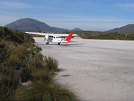
A tourist plane prepares for take-off from Melaleuca.
Population: 5
Postcode: none
Coordinates: 43°25′19.2″S 146°9′46.8″E / 43.422°S 146.163°E / -43.422; 146.163Coordinates: 43°25′19.2″S 146°9′46.8″E / 43.422°S 146.163°E / -43.422; 146.163 with
LGA: Huon Valley Council
State District: Franklin
Federal Division: Franklin

Melaleuca is a remote hamlet in the south-west area of Tasmania, Australia. Access is only by sea via Port Davey, by air[1] or by foot.

The settlement consists of a couple of buildings and a bird hide where the Orange-bellied Parrot can be viewed, and is a major tourist attraction. Melaleuca has a gravel airstrip which is used by small aircraft which service hiking needs and which bring tourists to the remote South West Wilderness region of the state. Two hiking trails meet at Melaleuca: the Port Davey Track and the South Coast Track. There are no shops nor any facilities apart from two walkers' huts. Camping is available nearby.

From the 1930s until the area gained World Heritage status, Melaleuca had been the location leased for mining ventures.[2]

Looking west from Melaleuca to the Bathurst Range

Deny King

From 1936 until his death in 1991, Melaleuca was home to tin miner Deny King who discovered the extinct shrub, Banksia kingii as well as a species of eyebright, Euphrasia kingii and the endangered King's lomatia or King's holly, Lomatia tasmanica. King also built the walkers' accommodation and airstrip and in 1975 was made a Member of the Order of Australia for his services to the community.

References

  1. ^ "Visitors Guide to Tasmania's National Parks - Southwest National Park". Tasmania Parks and Wildlife Service. http://www.parks.tas.gov.au/natparks/southwest/index.html. Retrieved 2007-03-12. 
  2. ^ King, C.D. and Fenton, J. Small Mining Settlements; pp. 48-53 in Gee, Helen and Fenton, Janet (eds) (1978) The South West Book: A Tasmanian Wilderness. Hawthorn, Vic: Australian Conservation Foundation. ISBN 0858020548; later edition, same title (1983) Sydney, NSW: William Collins Pty. Ltd., ISBN 0002173050; also Thwaites, J.B., King of the South-West (Jack King, tin miner at Melaleuca) pp. 57-60; also Mattingley, C. King of the Wilderness (2001) ISBN 1-877008-41-9

Wikimedia Foundation. 2010.

Игры ⚽ Нужен реферат?

Look at other dictionaries:

  • Melaleuca (disambiguation) — Melaleuca may refer to: Melaleuca, plant genus in the Myrtaceae family containing the paperbarks Places Melaleuca, Tasmania, south west Tasmania, Australia Melaleuca to Birchs Inlet Important Bird Area Melaleuca, Western Australia Melaleuca Field …   Wikipedia

  • Melaleuca ericifolia — Scientific classification Kingdom: Plantae (unranked): Angiosperms (unranked): Eudicots …   Wikipedia

  • Melaleuca squarrosa — Scented Paperbark Melaleuca squarrosa at Langwarrin, Victoria Scientific classification Kingdom …   Wikipedia

  • Melaleuca to Birchs Inlet Important Bird Area — The IBA is an important area for Hooded Plovers The Melaleuca to Birchs Inlet Important Bird Area comprises a 2315 km2 section of coast and sub coastal land in South West Tasmania. It stretches southward from the southern end of Birchs Inlet …   Wikipedia

  • Melaleuca — For other uses, see Melaleuca (disambiguation). Melaleuca M. armillaris foliage and flowers Scientific classification Kingdom …   Wikipedia

  • Melaleuca squamea — Swamp Honey myrtle In flower Scientific classification Kingdom: Plantae …   Wikipedia

  • Long Island (Tasmania) — Long Island is a granite and dolerite island, with an area of 313 ha, in south eastern Australia. It is part of Tasmania’s Long Island Group, lying in eastern Bass Strait north west of Cape Barren Island in the Furneaux Group.HistoryThe island… …   Wikipedia

  • South Coast Tasmania — South Coast TasmaniaIs a term used in Tasmania which is sometimes conflated with the South West Tasmania wilderness region. South East Cape is commonly used as a reference point of the eastern limit, and South West Cape the western end.ee… …   Wikipedia

  • Anderson Island (Tasmania) — Anderson Island, also known as Woody Island, is a granite island, with an area of 166 ha, in south eastern Australia. It is part of Tasmania’s Tin Kettle Island Group, lying in eastern Bass Strait between Flinders and Cape Barren Islands in the… …   Wikipedia

  • Great Dog Island (Tasmania) — Great Dog Island, also known as Big Dog Island, is a granite island, with an area of 354 ha, in south eastern Australia. It is part of Tasmania’s Great Dog Island Group, lying in eastern Bass Strait between Flinders and Cape Barren Islands in the …   Wikipedia

Share the article and excerpts

Direct link
Do a right-click on the link above
and select “Copy Link”