- Golden, British Columbia
Infobox Settlement
official_name = Town of Golden
other_name =
native_name =
nickname =
settlement_type = Town
motto =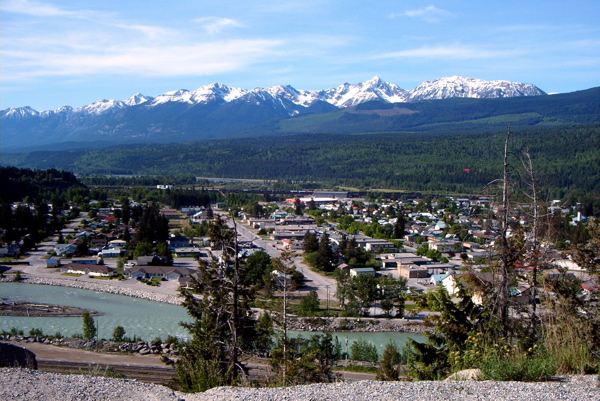
imagesize =
image_caption = Golden, British Columbia
flag_size =
image_
seal_size =
image_shield =
shield_size =
city_logo =
citylogo_size =
mapsize =
map_caption =
mapsize1 =
map_caption1 =
image_dot_
dot_mapsize =
dot_map_caption = Location of Golden inBritish Columbia
dot_x = 150 |dot_y = 122
pushpin_
pushpin_label_position =
pushpin_map_caption =
pushpin_mapsize =
subdivision_type = Country
subdivision_name = CAN
subdivision_type1 = Province
subdivision_name1 = BC
subdivision_type2 = Region
subdivision_name2 =Columbia Valley
subdivision_type3 = Regional District
subdivision_name3 = Columbia-Shuswap
subdivision_type4 =
subdivision_name4 =
government_footnotes =
government_type =
leader_title = Mayor
leader_name = Jim Doyle
leader_title1 = Governing Body
leader_name1 = Golden Town Council
leader_title2 = MP
leader_name2 = Jim Abbott (Cons-Kootenay/Columbia)
leader_title3 = MLA
leader_name3 = Norm Macdonald (NDP-Columbia/Revelstoke)
leader_title4 =
leader_name4 =
established_title = Incorporated
established_date = 1957
established_title2 =
established_date2 =
established_title3 =
established_date3 =
area_magnitude =
unit_pref =
area_footnotes =
area_total_km2 = 11.02
area_land_km2 =
area_water_km2 =
area_total_sq_mi =
area_land_sq_mi =
area_water_sq_mi =
area_water_percent =
area_urban_km2 =
area_urban_sq_mi =
area_metro_km2 =
area_metro_sq_mi =
area_blank1_title =
area_blank1_km2 =
area_blank1_sq_mi =
population_as_of = 2006
population_footnotes = [ [http://www12.statcan.ca/english/census06/data/profiles/community/Details/Page.cfm?Lang=E&Geo1=CSD&Code1=5939007&Geo2=PR&Code2=59&Data=Count&SearchText=Golden&SearchType=Begins&SearchPR=01&B1=All&Custom= 2006 Community Profiles] ]population_note =
population_total = 3,811
population_density_km2 = 345.7
population_density_sq_mi =
population_metro =
population_density_metro_km2 =
population_density_metro_sq_mi =
population_urban =
population_density_urban_km2 =
population_density_urban_sq_mi =
population_blank1_title =
population_blank1 =
population_density_blank1_km2 =
population_density_blank1_sq_mi =
timezone =Mountain Time Zone
utc_offset = -7
timezone_DST = Mountain Daylight Time
utc_offset_DST = -6
latd= 51 |latm= 18 |lats= 7 |latNS=N
longd= 116|longm= 58|longs= 0|longEW=W
coordinates_display = inline,title
coordinates_type = type:city_region:CA-BC_scale:60000
elevation_footnotes =
elevation_m = 800
elevation_ft =
postal_code_type = Postal code span
postal_code = V0A
area_code = +1-250
blank_name =
blank_info =
blank1_name =
blank1_info =
website = [http://www.town.golden.bc.ca/ Town of Golden Home Page]
footnotes =Golden is a town in southeastern
British Columbia ,Canada , located 262 kilometres (163 miles) west ofCalgary ,Alberta and 713 kilometres (443 miles) east ofVancouver . Much of the town's history is tied into theCanadian Pacific Railway and thelogging industry. Today, the town's economy still relies heavily on those two influences, but the development ofKicking Horse Resort , along with other outdoor adventure companies, has allowed the town to diversify into tourism. Mt.7 which is just south-east of town is popular with paragliding, hang gliding, and mountain biking enthusiasts. Golden is also home to one of the campuses of theCollege of the Rockies .Golden is nestled in the
Columbia Valley built around the confluence of theColumbia River andKicking Horse River , surrounded by three different mountain ranges and five National Parks;Yoho National Park ,Banff National Park ,Jasper National Park , Glacier National Park, andKootenay National Park .Golden is located on Highway 1 (the
Trans-Canada Highway ) and it is the terminus of Highway 95, connecting it to the United States.Kicking Horse Pedestrian Bridge is the longest freestanding timber frame bridge in Canada. [cite web
url=http://www.tourismgolden.com/activities/other/142
title=Kicking Horse Pedestrian Bridge
publisher=Tourism Golden
accessdate=2008-08-21] Planned as a community project by the [http://www.tfguild.org/ Timber Framer's Guild] , volunteers from Golden were joined by carpenters and timber framers from the United States and from Europe. The bridge structure is convert|150|ft|m long, with a 210,000-poundBurr arch structure. The bridge was completed in September 2001.References
External links
* [http://www.town.golden.bc.ca/ Town of Golden] (official website)
* [http://www.TourismGolden.com/ Tourism Golden] (official website)
* [http://www.murraytimber.com/bridge.htm Construction of the covered bridge]
Wikimedia Foundation. 2010.