- Martinsburg Formation
-
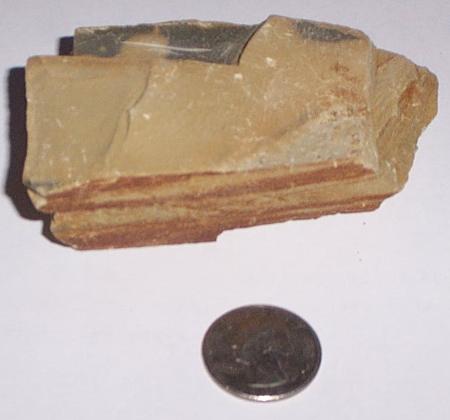
 A sample of the Martinsburg shale from the Pennsylvania Turnpike (Northeast Extension) at mile post 66.
The Ordovician Martinsburg Formation (Om) is a mapped bedrock unit in Pennsylvania, New Jersey, Maryland, Virginia, and West Virginia. It is named for the town of Martinsburg, West Virginia for which it was first described. It is the dominant rock formation of the Great Valley in Pennsylvania.
Contents
Description
The Martinsburg is defined as a gray to dark gray, and infrequently tan and purple shale and slate. Local members of impure sandstone; thin, argillaceous limestone or phyllitic shale are present in the Cumberland Valley and the Lehigh Valley.[1]
The Martinsburg has three defined members in the Lehigh Valley: The Bushkill Member which is defined as the basal slate unit. The Ramseburg Member which is composed on alternating turbitide sandstone units with interbeds of shale and siltstone. The Pen Argyl Member, which the upermost slate unit with some minor phyllite and shale beds.[2]
Depositional environment
The shales (and slates) of the Martinsburg were deposited in a large forearc basin resulting in a flysch deposit. This basin was the result of a deepening sea due to the closing of the Iapetus Ocean. Turbidites are common in the Martinsburg due to underwater landslides stirring up sediments and rushing down a slope. Limestones were deposited upon peripheral bulges in the deep seas. A modern analog to the depositional history of the Martinsburg can be the Australia-East Timor tectonic setting.[3]
Fossils
In the Pen Argyl Member, both Graptolites and Conodonts are found.[2] The Trilobite Cryptolithus and the brittle star Protasterina are common the Swatara Gap area.[4]
Age
The Martinsburg was deposited during the Upper Ordovician period between 457 and 445 (±5) million years ago. Near Hamburg PA, an allochthonous klippe of rocks (known as the Hamburg klippe) is a techtonic slice of Middle Ordovician sediments placed within the Martinsburg. The Martinsburg lies above and below erosinal unconformities. The Shawangunk Formation, Tuscarora Formation, and the Juniata Formation, all lie unconformably atop the Martinsburg. Below it, the Chambersburg Formations and Myerstown Formations lie on a possible unconformity.[5]
Economic Uses
Slate is still quarried out of the Martinsburg in the slate belt of Pennsylvania. Other quarries that exist in the shale partings use the rock as crushed stone for structural and other earth fill operations.
References
- ^ Berg, T.M., Edmunds, W.E., Geyer, A.R. and others, compilers, (1980). Geologic Map of Pennsylvania: Pennsylvania Geologic Survey, Map 1, scale 1:250,000.
- ^ a b Epstein, J.B., Sevon, W.D., Glaeser, J.D. (1974). Geology and the Mineral Resources of the Lehighton and Palmerton Quardrangles, Carbon and Northampton Counties, Pennsylvania. The Pennsylvania Geologic Survey, Harrisburg, PA. A195c&d.
- ^ Diecchio, R.J., (1993). Stratigraphic Interpretation of the Ordovician of the Appalachian Basin and Implications for Taconian Flexural Modeling. Tectonics, Vol. 12 N. 6, p. 1410-1419.
- ^ Pennsylvania Geology. The Great Swatara Gap Fossil Migration. Pennsylvania Geologic Survey, Harrisburg, PA. v 34, n 3.
- ^ Berg, T.M., et al., (1983). Stratigraphic Correlation Chart of Pennsylvania: G75, Penssylvania Geologic Survey, Harrisburg, Pennsylvania.
See also
Categories:- Geologic formations of the United States
- Geology of Pennsylvania
- Geology of New Jersey
- Geology of Maryland
- Geology of Virginia
- Geology of West Virginia
- Shale
- Slate
- Geologic formation stubs
Wikimedia Foundation. 2010.