- Compromise Township, Champaign County, Illinois
-
Compromise Township — Township — Location in Champaign County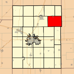 Champaign County's location in Illinois
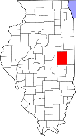
Coordinates: 40°15′57″N 88°00′46″W / 40.26583°N 88.01278°WCoordinates: 40°15′57″N 88°00′46″W / 40.26583°N 88.01278°W Country United States State Illinois County Champaign Area - Total 48.11 sq mi (124.61 km2) - Land 48.11 sq mi (124.61 km2) - Water 0 sq mi (0 km2) 0% Elevation 709 ft (216 m) Population (2000) - Total 1,422 - Density 29.6/sq mi (11.4/km2) Time zone CST (UTC-6) - Summer (DST) CDT (UTC-5) GNIS feature ID 0428835 Compromise Township is a township in Champaign County, Illinois, USA. As of the 2000 census, its population was 1,422[1].
Contents
History
Compromise Township formed from parts of Kerr Township and Rantoul Township on an unknown date.
Geography
Compromise Township covers an area of 48.11 square miles (124.6 km2).
Cities and towns
- Gifford (south three-quarters)
Unincorporated towns
(This list is based on USGS data and may include former settlements.)
Cemeteries
The township contains five cemeteries: Huls, Kopman, Leal Park, Saint Lawrence and Welles.
Major highways
Airports and landing strips
- Busboom Airport
References
- "Compromise Township, Champaign County, Illinois". Geographic Names Information System, U.S. Geological Survey. http://geonames.usgs.gov/pls/gnispublic/f?p=gnispq:3:::NO::P3_FID:0428835. Retrieved 2010-01-04.
- United States Census Bureau cartographic boundary files
- Illinois State Archives
External links

Harwood Township Kerr Township Rantoul Township 
Middlefork Township, Vermilion County
Pilot Township, Vermilion County Compromise Township

Stanton Township Ogden Township Municipalities and communities of Champaign County, Illinois County seat: Urbana Cities 
Villages Townships Unincorporated
communitiesAugerville | Block | Bongard | Dailey | Deers | Dewey | Dickerson | Dillsburg | Fairland‡ | Flatville | Fulls | Gerald | Giblin | Glover | Jimtown | Lake of the Woods | Leverett | Lotus | Mayview | Mira | Parkville | Pauline | Penfield | Prospect | Rising | Rutherford | Sellers | Seymour | Sloan Station | Staley | State Road | Tipton | Tomlinson | Wilbur Heights
Footnotes ‡This populated place also has portions in an adjacent county or counties
Categories:- Townships in Champaign County, Illinois


Wikimedia Foundation. 2010.