- Open Geospatial Consortium
-
The Open Geospatial Consortium (OGC), an international voluntary consensus standards organization, originated in 1994. In the OGC, more than 400 commercial, governmental, nonprofit and research organizations worldwide collaborate in a consensus process encouraging development and implementation of open standards for geospatial content and services, GIS data processing and data sharing.
Contents
History
A predecessor organization, OGF, the Open GRASS Foundation, started in 1992.[1]
From 1994 to 2004 the organization also used the name Open GIS Consortium.
The OGC website gives a detailed history of the OGC.[2]
Standards
Most of the OGC standards depend on a generalized architecture captured in a set of documents collectively called the Abstract Specification, which describes a basic data model for representing geographic features. Atop the Abstract Specification members have developed and continue to develop a growing number of specifications, or standards to serve specific needs for interoperable location and geospatial technology, including GIS.
More information here: http://www.opengeospatial.org/standards
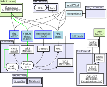 Relationship between clients/servers and some OGC protocols
The OGC standards baseline comprises more than 30 standards,[3] including:
- OGC Reference Model - a complete set of reference models
- WMS - Web Map Service: provides map images
- WMTS - Web Map Tile Service: provides map image tiles
- WFS - Web Feature Service: for retrieving or altering feature descriptions
- WCS - Web Coverage Service: provides coverage objects from a specified region
- WPS - Web Processing Service: remote processing service
- CSW - Catalog Service for the Web: access to catalog information
- SFS - Simple Features - SQL
- GML - Geography Markup Language: XML-format for geographical information
- Styled Layer Descriptor (SLD)
- KML - Keyhole Markup Language: XML-based language schema for expressing geographic annotation and visualization on existing (or future) Web-based, two-dimensional maps and three-dimensional Earth browsers
- Sensor Observation Service[4] (SOS)
- Sensor Planning Service[5] (SPS)
- SensorML - Sensor Model Language
- Observations and Measurements
- OWS - OGC Web Service Common
- GeoXACML - Geospatial eXtensible Access Control Markup Language (as of 2009[update] in the process of standardization)
The design of standards were originally built on the HTTP web services paradigm for message-based interactions in web-based systems. However, in the last year[vague] the members have started working on defining a common approach for SOAP protocol and WSDL bindings. Considerable progress has been made in defining Representational State Transfer (REST) web services.
Organization structure
The OGC has three operational units:
- the Specification program
- the Interoperability Program
- Outreach and Community Adoption
Collaboration
The OGC has a close relationship with ISO/TC 211 (Geographic Information/Geomatics). Volumes from the ISO 19100 series under development by this committee progressively replace the OGC abstract specification. Further, the OGC standards Web Map Service, GML and Simple Features Access have become ISO standards.[citation needed]
The OGC works with more than 20 international standards-bodies including W3C, OASIS, WfMC, and the IETF.[citation needed]
See also
- GeoTools - implements OGC standards as OGC releases them
- Open Source Geospatial Foundation (OSGeo)
- List of geographic information systems software
- Comparison of geographic information systems software
- OpenLayers
- Semantic Sensor Web
References
- ^ GRASS Roots, Westervelt, p. 5
- ^ http://www.opengeospatial.org/ogc/historylong
- ^ "OGC Standards and Related Documents". http://www.opengeospatial.org/standards/.
- ^ "OGC Standard - Sensor Observation Service". 2008. http://www.opengeospatial.org/standards/sos. Retrieved 2008-10-29.
- ^ "OGC Standard - Sensor Planning Service". 2010. http://www.opengeospatial.org/standards/sps. Retrieved 2010-04-14.
External links
- Open Geospatial Consortium
- OpenGIS(R) Abstract Specification by OGC
- OpenGIS(R) Specifications by OGC
- Open GPSToolKit.
- OGR - OGR library which implements relevant OGC standards (part of GDAL)
- ISO/TC 211
- Open Source GIS Master Index of Open Source GIS projects, many of which implement OGC standards
- ObjectFX
Categories:- Open Geospatial Consortium
- Earth sciences metadata conventions
- Standards organizations
- Geographic information systems organizations
Wikimedia Foundation. 2010.