- Arrondissement of Tielt
-
Arrondissement of Tielt
Arrondissement Tielt
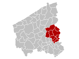
Arrondissement de Tielt— Arrondissement — Location of the arrondissement in West-Flanders
Coordinates: 51°00′N 3°18′E / 51.0°N 3.3°ECoordinates: 51°00′N 3°18′E / 51.0°N 3.3°E Country  Belgium
Region  Flemish Region
Province  West Flanders
Municipalities 9 Area – Total 329.79 km2 (127.3 sq mi) Population (1 January 2006) – Total 88,787 – Density 269.2/km2 (697.3/sq mi) Time zone CET (UTC+1) – Summer (DST) CEST (UTC+2) The Arrondissement of Tielt (Dutch: Arrondissement Tielt; French: Arrondissement de Tielt) is one of the eight administrative arrondissements in the Province of West Flanders, Belgium.
History
The Arrondissement of Tielt was created in 1818 and originally comprised the cantons of Ruiselede and Tielt, which were ceded from the Arrondissement of Bruges, and the canton of Meulebeke, which was ceded from the Arrondissement of Kortrijk. In 1823, the arrondissements of Torhout and Wakken ceased to exist and, as a result, a number of municipalities which had previously been a part of the Arrondissement of Torhout and the canton of Oostrozebeke were added to the arrondissement.
The municipality of Ardooie was added in 1977 from the Arrondissement of Roeselare.
Municipalities
The administrative arrondissement of Tielt consists of the following municipalities:
Administrative arrondissements of BelgiumBrussels-Capital Region Brussels-CapitalFlemish Region Aalst · Antwerp · Bruges · Dendermonde · Diksmuide · Eeklo · Ghent · Halle-Vilvoorde · Hasselt · Kortrijk · Leuven · Maaseik · Mechelen · Ostend · Oudenaarde · Roeselare · Sint-Niklaas · Tielt · Tongeren · Turnhout · Veurne · Ypres-Ieper
Walloon Region Categories:- West Flanders
- Arrondissements of Flanders
- West Flanders geography stubs
Wikimedia Foundation. 2010.