- Dymi, Achaea
-
Dymi
ΔύμηLocation 
 Dymi
DymiCoordinates 38°8′N 21°33′E / 38.133°N 21.55°ECoordinates: 38°8′N 21°33′E / 38.133°N 21.55°E Location within the peripheral unit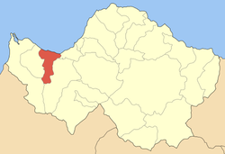
Government Country: Greece Region: West Greece Regional unit: Achaea Municipality: West Achaea Population statistics (as of 2001) Municipal unit - Population: 10,664 - Area: 71.55 km2 (28 sq mi) - Density: 149 /km2 (386 /sq mi) Other Time zone: EET/EEST (UTC+2/3) Elevation (center): 20 m (66 ft) Postal: 252 00 Telephone: 26930 Auto: ΑΧ Website www.dymi.gr Dymi (Greek: Δύμη) is a former municipality in Achaea, West Greece, Greece. Since the 2011 local government reform it is part of the municipality West Achaea, of which it is a municipal unit.[1] Its seat of administration was the town of Kato Achaia. It is located 22 km SW of Patras, 242 km W of Athens and 74 km (old 78 km) NE of Pyrgos.
Contents
Population history
Year Municipality Dymi 1991 8,765 2001 10,664 Subdivisions
The municipal unit Dymi is subdivided into the following communities (constituent villages in brackets):
- Kato Achaia (Kato Achaia, Alykes, Manetaiikia, Paralia Kato Achaias, Piso Sykea)
- Agiovlasitika (Agiovlasitika, Kapeli, Lefkos, Stenaitika)
- Alissos (Alissos, Kamenitsa, Paralia Alissou, Profitis Elissaios)
- Ano Achaia
- Elaiochori
- Kato Alissos (Kato Alissos, Gialos)
- Niforeika (Niforeika, Paralia Niforeikon)
- Petrochori (Petrochori, Veskoukaiika, Vythoulkas, Zampeteika, Karya, Lampraiika, Logothetis)
Sporting teams
- Achaikos - third division
See also
References
- ^ Kallikratis law Greece Ministry of Interior (Greek)
External links
North: Gulf of Patras West: Movri Dymi East: Vrachnaiika, Olenia South: Olenia Subdivisions of the municipality of West Achaea Municipal unit of Dymi Agiovlasitika · Alissos · Ano Achaia · Elaiochori · Kato Achaia · Kato Alissos · Niforeika · PetrochoriMunicipal unit of Larissos Municipal unit of Movri Municipal unit of Olenia Achaiko · Agios Nikolaos Kralis · Agios Stefanos · Ano Soudenaiika · Arla · Chaikali · Charavgi · Fostaina · Galanaiika · Gkaneika · Kato Mazaraki · Lousika · Mitopoli · Portes · SantomeriCategories:- Populated places in Achaea
- Dymi
- Ancient Greek cities


Wikimedia Foundation. 2010.