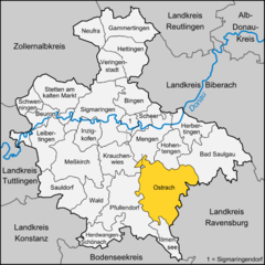
- Ostrach
-
Ostrach 
Coordinates 47°57′9″N 9°22′53″E / 47.9525°N 9.38139°ECoordinates: 47°57′9″N 9°22′53″E / 47.9525°N 9.38139°E Administration Country Germany State Baden-Württemberg Admin. region Tübingen District Sigmaringen Local subdivisions 9 Mayor Christoph Schulz Basic statistics Area 108.93 km2 (42.06 sq mi) Elevation 611 m (2005 ft) Population 6,714 (31 December 2010)[1] - Density 62 /km2 (160 /sq mi) Other information Time zone CET/CEST (UTC+1/+2) Licence plate SIG Postal codes 88354–88356 Area code 07585 Website www.ostrach.de Ostrach is a municipality in the district of Sigmaringen in Baden-Württemberg in Germany.
Geography
Ostrach lies between the Danube and Lake Constance, about halfway between Sigmaringen and Ravensburg. It lies on the brook of the same name, which passes through a narrow pass between the glacial moraines left by the Rhine Glacier at the end of the last Ice Age. The landscape is hilly and wooded. Abandoned quarries to the north and south of the village of Jettkofen have created small lakes.
History
The first mention of Ostrach occurs in 851. In the 13th century, the area passed gradually from the Holy Roman Empire into the hands of the monastery of Salem.
On March 21, 1799, the Austrian and French troops fought a battle at Ostrach. In 1803, in the German Mediatisation, Ostrach and Bachhaupten passed into the hands of the house of Thurn und Taxis, and in 1806 they were incorporated into the lands of the house of Hohenzollern-Sigmaringen.
The railway line Altshausen-Ostrach-Pfullendorf opened in 1875. The last freight train passed through Ostrach on July 31, 2002.
On January 1, 1975, the surrounding villages of Burgweiler (with Dichtenhausen, Hahnennest, Ochsenbach, Waldbeuren, Ulzhausen, Egelreute), Einhart, Habsthal (with Bernweiler), Jettkofen, Kalkreute, Laubbach, Levertsweiler, Magenbuch (with Lausheim), Spöck, Tafertsweiler (with Bachhaupten, Eschendorf, and Gunzenhausen), Wangen, and Wirnsweiler were incorporated into Ostrach.
Bad Saulgau | Beuron | Bingen | Gammertingen | Herbertingen | Herdwangen-Schönach | Hettingen | Hohentengen | Illmensee | Inzigkofen | Krauchenwies | Leibertingen | Mengen | Meßkirch | Neufra | Ostrach | Pfullendorf | Sauldorf | Scheer | Schwenningen | Sigmaringen | Sigmaringendorf | Stetten am kalten Markt | Veringenstadt | WaldReferences
- ^ "Bevölkerung und Erwerbstätigkeit" (in German). Statistisches Landesamt Baden-Württemberg. 31 December 2009. http://www.statistik-bw.de/Veroeffentl/Statistische_Berichte/3126_10001.pdf.
Categories:- Geography articles needing translation from German Wikipedia
- Municipalities in Baden-Württemberg
- Towns in Baden-Württemberg
- Sigmaringen district
- Tübingen region geography stubs
Wikimedia Foundation. 2010.


