- Lora, NWFP
Union Councils
name = Lora
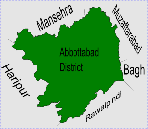
caption = Lora is located in Abbottabad District
province =NWFP
district = Abbottabad
tehsil = Havelian
nazim = khan Bilal Hameed Khan [http://www.abbottabad.gov.pk/Union-council/UCDetailPage.asp?name=Lora Lora Union Council] ]
naib nazim = Khalid Munir Abbasi
population =
coordinates = coord|33|53|0|N|73|17|0|E|type:rural_region:PK|display=inline,titleLora is one of the 51 Union Councils ofAbbottabad District in theNorth-West Frontier Province ofPakistan . [ [http://www.abbottabad.sdnpk.org/adminunit.htm Administrative Units of District Abbottabad] ] Lora Union Council takes it name from the main village of area. The Local language isHindko butUrdu is also universally understood.Location
Lora is located at an altitude of 1138 metres (3736 feet). [ [http://www.fallingrain.com/world/PK/3/Bagnotar.html Falling Rain Genomics - Location of Lora] ] It is situated in the southern part of Abbottabad District in
Havelian Tehsil it is bounded by the following union councils, Nara to the north,Nagri Totial to the north and east,Goreeni to the south, andPhallah to the west.UC Lora is bisected by
Nadi Haro (on which theKhanpur Dam is built). Locals grow seasonal crops such as Maize (makai) and Wheat (gandum).Education
The literacy rate of Lora is high compared to other villages of NWFP and it is also home to a government high school which was a centre of excellence. Lora has produced one of the first female engineers, who after leaving Lora High School went to London to read
Electronic Engineering , but now the quality of education is than before. Due to this situation people with economic means prefer to educate their siblings inRawalpindi ,Islamabad or Abbottabad. A large number of people from Lora have migrated to the cities of Karachi, Abbottabad and Islamabad as well as emigrating abroad in search of a better life.ubdivisions
The Union Council of Lora is subdivided into the following areas: Ghari, Ghora, Dheri Kiala, Lora, Narhota, Noorpur, Seri and Thath Karam Shah.Lora is connected with Abbottabad via the
Ghora Gali -Shah Maqsood road, the travelling time from Abbottabad is about 3 hours by Bus and two hours by car.Murree is about 22km from Lora and can be reached in 40 mins.Well Known personalities of Lora Khan Abdul Hameed Khan,Bashir Ahamad Abbasi,Col(R)AbdulRazaq Abbasi(Late),Col(R)Javed Abdul Ghafar,Master Muhammad Mahmood.History
Lora has always been an important place and also a business hub of
Circle Lora which consists of six union councils (Lora, Goreeni, Phallah, Nagri Tutial,Seer Sharqi andSeer Gharbi ). It lies at the peripheral boundary of Abbottabad and most of the people work inIslamabad due to easy access by road through the Ghora Gali- Rawalpindi road. It also has importance due to the politicians of this area playing an important role in the politics of District, Provincial and at National level. Sardar Anyat-u-Rehman Abbasi was the first Parliamentarian ofCircle Bakote who received a grant from theAyub Khan Government - and established many primary, middle and high schools. The Upper Dewal- Kohala Road and Ghora Gali-Lora Road were also constructed in 1964 and completed by 1968 due to his efforts. He also wanted to create aSowar Gali to Boi Road but this did not come into being.References
Wikimedia Foundation. 2010.