- Damak
-
Damak
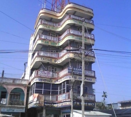
दमक— Municipality — 7 Story Building of Thana Road Location in Nepal
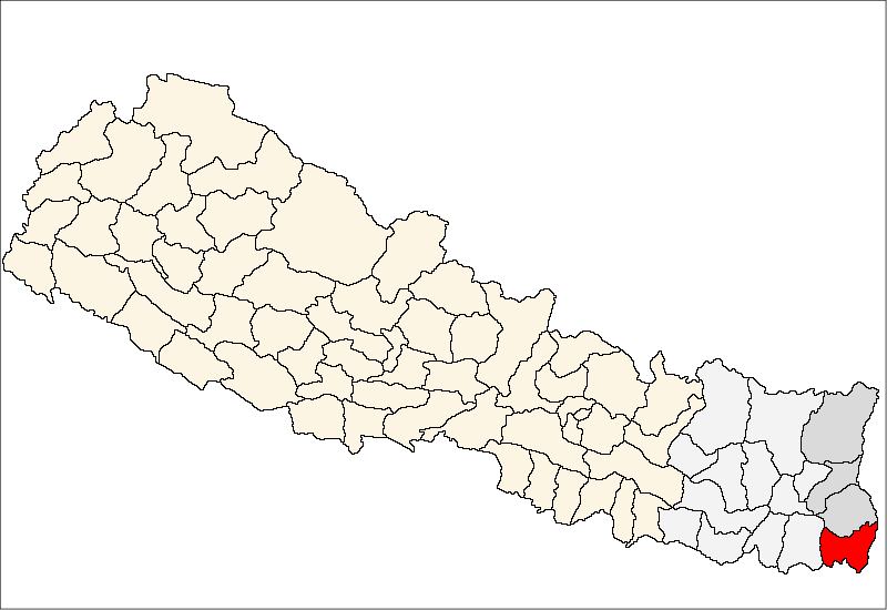
 Damak
DamakCoordinates: 26°38′N 87°42′E / 26.63°N 87.70°ECoordinates: 26°38′N 87°42′E / 26.63°N 87.70°E Country  Nepal
NepalZone Mechi Zone District Jhapa District Area - Total 75.13 km2 (29 sq mi) Elevation 71 m (233 ft) Population (2001) - Total 35,009 - Density 466/km2 (1,206.9/sq mi) Time zone Nepal Time (UTC+5:45) Area code(s) 023 Damak (Nepali: दमक) is a town and municipality in Jhapa District in the Mechi Zone of south-eastern Nepal. It is situated between the Ratuwa River in the east and the Mawa River in the west. As of 2001 census total population of city is 35,009. At the time of the 1991 Nepal census it had a population of 41,321 people living in 7,644 individual households.[1]
Damak was changed to a municipality from a VDC (Village Development Committee) in the year 1982 AD. The Damak municipality consists of 19 wards which also includes the large Himalayan Tea State (हिमालय गूडरिक) where the Ex-Royal Family has also invested. The municipality covers an area of 7,513 hectares and is at an average of 100 meters above the sea level. Lakhanpur in to the east, Urlabari, Rajghat and Madhumalla in the west and Chulachuli (Ilam) and Kohabhara VDC in the north and the south, respectively.
According to the census of 2001, Damak had 7,178 households containing about 35,000 people. The total area is 7,513 hectares out of which 1406.7 hectares is covered by residential area whereas 5,586.30 hectares is used for agriculture. The market area consists of 400.00 hectares, 215 hectares as forest plant area and 265.00 hectares is used in other purposes. In 056/057 there was 1 Health post, 1 Hospital (AMDA) and 1 Nursing Home (Life Line) which contains 50 beds in total. The Population Growth Rate is 5.14 per annum as per 2047/48 census. As per 056/057 census, there were about 88 industries, 1011 shops, 244 hotels and 9 financial institutions. Black topped road were 29 km, graveled roads were 150 km and earthen road were 500 km. In addition to it, the drainage runs 3.5 km through the main highway. There are 512 street lights and 1,114 telephone lines to public.Three bhutanse refugee camp(beldangi 1, 2, and 3) was also settled in damak in 1992.
It is one of the important trade center in eastern part of Nepal. There are many international organizations such as IOM, UNHCR, OX-FARM, LWF, NRCS, AMDA,CARITAS NEPAL etc. who are working for the refugees here in Damak.
Contents
Education
According to 2001 census literacy rate of city is 88 %. [2]
Damak Multiple Campus is oldest campus in the city established in 1981. Its only the campus offering education up to Master's Degree. Other well known colleges include Model Campus Damak and Unique College having program up to Bachelor's Degree. Damak Multiple Campus and Model Campus Damak are affiliated to Tribhuvan University whereas Unique college is affiliated to Purbanchal University, Nepal. Notable Schools in Damak are Suryodaya English School, Siddhartha Higher Secondary School, Chulachuli Boarding School and Himalya Higher Secondary School.
School Data
- Primary - 38
- Lower Secondary - 7
- Secondary - 9
- Technical School Under CTEVT - 2
- Higher Secondary - 15
- Affiliated Campus - 3
- University - 0
Communication and entertainment
Nepal Telecom Damak Branch serves as the center for Telecommunication and Cellular. Whereas Spices Nepal's Ncell is also popular in the city.
Damak has three film halls,
- Pathibhara Chalchitra Bhawan, Ward no 10
- Damak Chitramandir, Ward no 11
- Nilkantha Chitra Mandir, Ward no 12, Bazar
Pathibhara & Nilkantha most of the time shows nepali movies, whereas Damak chitra mandir shows new Hindi movies most of the times. Damak is considered one of the good out of valley market for Nepali film.
Damak has two FM stations named Saptarangi FM and Pathibhara FM. [3]. But national radio station Radio Nepal and other surrounding FM stations Kanchanjungha FM, Saptakoshi FM, Koshi FM, Kantipur FM can clearly be heard in the city.
Neighborhood
- Damak Chowk (City Center)
- Kirat Chowk
- Aaitabare
- Bahraghare
- Tallo Bazar
- Mathlo Bazar
- Chiyabagan
- Dhukurpani
- Adiyamol
- Janta Chowk
- Krishnamandir
- Dakini
- Golatar
Notable Residents
- Ram Bahadur Limbu, Victoria Cross winner
- Laxmi Joshi, Singer of "Riting Riting Nabajau Binayo"
- KP Sharma Oli, Seniour Leader, CPN UML
See also
Jhapa
BiratnagarReferences
- ^ "Nepal Census 2001". Nepal's Village Development Committees. Digital Himalaya. http://www.digitalhimalaya.com/collections/nepalcensus/form.php?selection=1. Retrieved 24 November 2008.
- ^ "Nepal Census 2001". http://www.digitalhimalaya.com/collections/nepalcensus/form.php?selection=28.
- ^ "Saptarangi FM official website". theowner. http://www.saptarangifm.com/radio/index.html. Retrieved 21 Oct 2010.[dead link]
Anarmani · Arjundhara · Bahundangi · Baigundhara · Balubari · Baniyani · Bhadrapur · Budhabare · Chakchaki · Charpani · Damak · Dangibari · Dhaijan · Dharmpur · Dhulabari · Duhagadhi · Garamani · Gauradaha · Gauriganj · Ghailadubba · Gherabari · Golchhap · Haldibari · Jalthal · Juropani · Jyamirgadhi · Kankarbhitta · Kechana · Khajurgachhi · Khudnabari · Kohabara · Korabari · Kumarkhod · Lakhanpur · Mahabhara · Maharanijhoda · Maheshpur · Mechinagar · Panchganchi · Pathabhari · Pathariya · Prithivinagar · Rajghadh · Sanischare · Satasidham · Shantinagar · Sharanamati · Shivaganj · Surunga · Taganduba · Topgachchi

Radio: Saptarangi FM 101 MHz Damak 11, Jhapa Nepal Phone no. +977 23 584926, 584626 Fax: +977 23 584927 Radio: Pathivara FM 93.6 MHz Damak 10, Jhapa Nepal.
Categories:- Populated places in Jhapa District
- Populated places in Nepal

Wikimedia Foundation. 2010.