- Calabazas Creek
Geobox|River
name = Calabazas Creek
native_name =
other_name =
category =stream
etymology = Spanish
nickname =
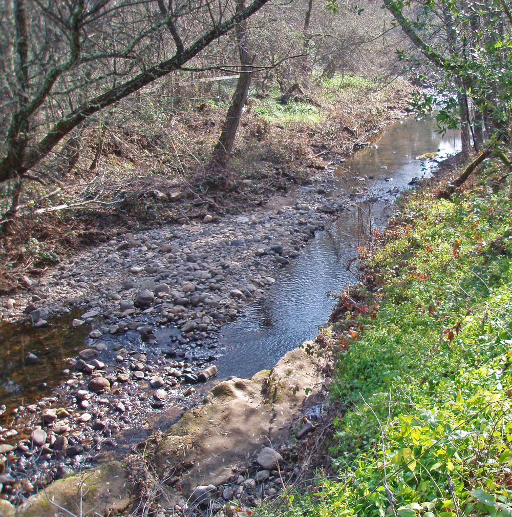
image_caption = Calabazas Creeksteelhead run area immediately upstream ofconfluence withSonoma Creek .
country =United States
state =California
region = Sonoma County
district =
municipality =
parent =
tributary_right =
tributary_left = Stuart Creek
city =Glen Ellen, California
landmark =
river =
source =Mayacamas Mountains
source_location = convert|4|mi|km|0|lk=on|abbr=on northeast ofGlen Ellen, California
source_region = | source_country =
source_elevation_imperial = 530
source_elevation_note =
source_lat_d = 38 | source_lat_m = 23 | source_lat_s = 54 | source_lat_NS = N
source_long_d = 122 | source_long_m = 28 | source_long_s = 26 | source_long_EW = W
source_coordinates_note = gnis|254687|Calabazas Creek]
source1 =
source1_location = | source1_region = | source1_country =
source1_elevation_imperial =
source1_lat_d = | source1_lat_m = | source1_lat_s = | source1_lat_NS =
source1_long_d = | source1_long_m = | source1_long_s = | source1_long_EW =
source_confluence =
source_confluence_location = | source_confluence_region = | source_confluence_country =
source_confluence_elevation_imperial =
source_confluence_lat_d = | source_confluence_lat_m = | source_confluence_lat_s = | source_confluence_lat_NS =
source_confluence_long_d = | source_confluence_long_m = | source_confluence_long_s = | source_confluence_long_EW =
mouth =Sonoma Creek
mouth_location =Glen Ellen, California
mouth_region = | mouth_country =
mouth_elevation_imperial = 236
mouth_elevation_note =
mouth_lat_d = 38 | mouth_lat_m = 21 | mouth_lat_s = 45 | mouth_lat_NS = N
mouth_long_d = 122 | mouth_long_m = 31 | mouth_long_s = 29 | mouth_long_EW = W
mouth_coordinates_note =
length_imperial = 5.2
length_note =
length_orientation =
width_imperial = | width_orientation =
depth_imperial =
volume_imperial =
watershed_imperial = 7.7
watershed_note =
discharge_location =
discharge_location_note =
discharge_imperial =
discharge_round =
discharge_max_imperial =
discharge_min_imperial =
free = | free_type =
map_caption =
map_background =
map_locator =
map_locator_x =
map_locator_y =
website =
footnotes =Calabazas Creek is a
stream in theSonoma Valley ,California ,USA that rises in the southernMayacamas Mountains and empties intoSonoma Creek nearGlen Ellen, California . In theSpanish language , "calabazas" means squash or pumpkins.cite book|last=Durham|first=David L.|title=California's Geographic Names: A Gazetteer of Historic and Modern Names of the State|pages=page 610|publisher=Word Dancer Press|date=1998|isbn=1884995144]The upper reaches of Calabazas Creek are relatively pristine with a dense forest canopy of mixed
oak woodland , while the lower reaches on the Sonoma Valley floor have considerable encroachment by rural residential development,vineyard s and otheragricultural uses. One of Sonoma County's oldest stone archbridge s, from the year 1915, spans Calabazas Creek near Dunbar School. [ [http://bridgehunter.com/ca/sonoma/ Historic Bridges of Sonoma County, California] ] As of 2007 the Sonoma County Open Space District has acquired 1,290 acres (5.2 km²) in this watershed for conservation purposes, and is currently drawing up plans for futurepublic access Calabazas Creek has historically hosted a robust
steelhead run. [ [http://www.krisweb.com/biblio/nsfb_cdfg_xxxx_1961_calabazasflow.pdf 1961 Stream Survey and Hand-drawn] ] . As late as 2001 spawning gravel studies were conducted in Calabazas along with
Graham Creek , Bear Creek,Carriger Creek and mainstem Sonoma Creek; these studies demonstrated that adequacy of spawninggravel s and absence ofsedimentation are not limited factors foranadromous fish propagation. [ [http://www.sonomaecologycenter.org/Resources_prj/SEC_Projects.html Sonoma Ecology Center: Summary of Research Projects] ]Course
Calabazas Creek originates about convert|4|mi|km|0|lk=on|abbr=on northeast of the town of
Glen Ellen, California , just north of Trinity Road, at the top of Nunns Canyon. Its headwaters form from the convergence of several unnamedperennial stream s.Leidy, R.A, G.S. Becker and B.N. Harvey, " [http://www.cemar.org/pdf/wholedoc2.pdf Historical distribution and current status of steelhead/rainbow trout ("Oncorhynchus mykiss") in streams of the San Francisco Estuary] ", Center for Ecosystem Management, Oakland, Ca. (2005)] It descends in a westward direction through the canyon, augmented by the waters of Nunns Iron Spring and other tributaries, and parallels Nunns Canyon Road. It emerges into the Valley of the Moon and turns southward, passing under State Route 12 at milepost 29.41cite web|url=http://nationalbridges.com/|title=National Bridge Inventory Database] . It flows west of the town of Agua Caliente. As it parallels Henno Road soutward into Glen Ellen, it is fed by Stuart Creek. Just after it crosses Arnold Drive, it empties into Sonoma Creek.Geology
Up until about twelve million years ago, this location was part of the
seabed of thePacific Ocean . In theMiocene era, precipitated by the combination oftectonic movement due to theseismic ally active environment and the presence ofmagma not far below the earth's surface, a massive period ofuplift ensued. This uplift formed the volcanically basedMayacamas Mountains . Residual evidence of these ancient geological features appears in the form of scatteredoutcrop s ofbasalt andrhyolite as well as localhot springs such as nearby Mortons Hot Springs and Agua Caliente Hot Springs. ["Santa Rosa Quadrangle", Fifteen minute series,USGS Quadrangle Map, U.S. Government Printing Office, Washington DC (1958)] Some rockquarry ing was historically conducted near Nunns Canyon Road in the upper Calabazas Creek watershed.Upper reach
The upper reach can be defined as the portion of Calabazas Creek north of its crossing of State Route 12, which point lies approximately three miles upstream of the confluence with Sonoma Creek. Initially there are two large ranches on either side of Calabazas Creek: Beltane Ranch to the west and Atwood Ranch to the east. Proceeding upstream for the next mile, there is continuous close viewing of the creek, since Nunns Canyon Road runs near the top of the west stream banks. An abandoned rock quarry is situated about 0.3 miles (500 m) north of State Route 12 on the west bank.
Where Nunns Canyon Road terminates, Calabazas Creek enters into an 1,290 acre (5.2 km²) open space
nature preserve owned and managed by theSonoma County Open Space District; as of 2007, there is no public access to this prior holding of the Beltane Ranch, which has been named the Calabazas Creek Open Space Preserve. [ [http://www.revision2005.org/docManager/1000000142/chap5.pdf Summary of Holdings and Plans of the Sonoma County Open Space District] ] In addition to a relatively pristineriparian zone , the upper Calabazas Creek has a high qualityCalifornia oak woodland , much of which is an undisturbed ecosystem with considerablebiodiversity , particularly in the upper 1.7 miles (2.5 km) of the headwaters. Some of the steeply sloped forested areas are characterized as good examples of such woodlands, testifying to the absence of historicgrazing or otheragriculture .Besides the
riparian habitat, the dominant plant community is the oak woodland, which has a canopy ofcoast live oak ,Pacific Madrone ,Douglas fir ,Coast Redwood andCalifornia laurel . ["Ecology of the Southern Mayacmas Range", Lumina Technologies, Santa Rosa, Ca., May 11, 2005] In the oak woodlands, the dominantunderstory plants are nativetoyon ,blackberry andwestern poison-oak . Common animals observed includeBlack-tailed Deer ,gray squirrel ,jackrabbit ,raccoon ,skunk andopossum . Less frequentlymountain lion are seen. There is abundantbird life including thescrub jay ,Steller's jay ,Acorn woodpecker ,Black Phoebe andjunco . A number ofamphibian s occur near the creek and its tributary elements, including theRough skinned newt , "Taricha granulosa".ee also
*
Basalt
*List of watercourses in the San Francisco Bay Area
*Miwok References
Wikimedia Foundation. 2010.