Digital Cadastral DataBase
- Digital Cadastral DataBase
-
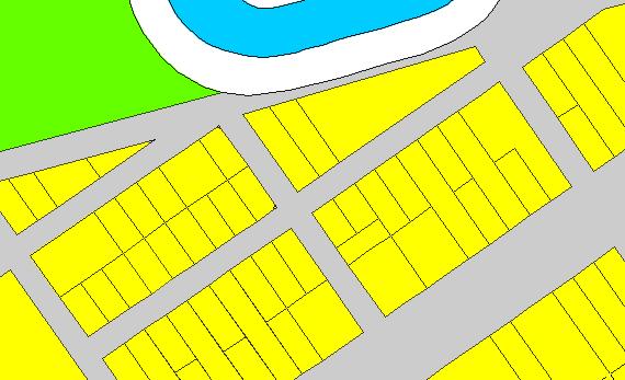
Digital Cadastral DataBase (DCDB) is a computerised map or 'spatial' location showing property boundaries normally in relation to adjoining and other close properties or parcels of land. Commonly used as a basic layer of data used in map based computer programs that gives an outline of the legal boundary of a property. By using lines to represent an area, features such as rivers and roads can be shown in relation to where a property is.

An example of a DCDB file showing properties, road easments and a watercourse
See also
Wikimedia Foundation.
2010.
Look at other dictionaries:
Cartography — Cartographer redirects here. For the album by E.S. Posthumus, see Cartographer (album). A nautical chart of the Mediterranean Sea from the second quarter of the 14th century. It is the oldest original cartographic artifact in the Library of… … Wikipedia
Pictorial maps — Recent example of Watercolour ink Geopictorial style illustrated map by Jean Louis Rheault Pictorial maps are a category of maps that are also loosely called illustrated maps, panoramic maps, perspective maps, bird’s eye view maps and… … Wikipedia
Topological map — Topological tube map of the London Underground In cartography and geology, a topological map is one that has been simplified so that only vital information remains and unnecessary detail has been removed. These maps lack scale, and distance and… … Wikipedia
Australian Capital Territory Planning and Land Authority — The Planning and Land Authority is an agency of the Government of the Australian Capital Territory, which advises the Minister for Planning, currently Andrew Barr. The Authority states that under the ACT Planning and Land Act 2002 , [cite web… … Wikipedia
Blom — Infobox Company company name = Blom ASA company company type = Public foundation = 1954 location = Oslo, Norway key people = Håkon Jacobsen (CEO) Dirk Blaauw (Chairman) area served = Europe industry = Cartography products = revenue = profit NOK… … Wikipedia
Topographic map — A topographic map with contour lines … Wikipedia
Geocoding — is the process of finding associated geographic coordinates (often expressed as latitude and longitude) from other geographic data, such as street addresses, or zip codes. With geographic coordinates the features can be mapped and entered into… … Wikipedia
Troisième dynastie d'Ur — Ruines de la cité d Ur, avec la ziggurat en arrière plan. La Troisième dynastie d’Ur (sous forme abrégée : Ur III) est, comme son nom l’indique, la troisième dynastie de la ville sumérienne d’Ur, selon la tradition historiographique… … Wikipédia en Français