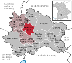
- Mammendorf
-
Mammendorf 
Coordinates 48°12′N 11°11′E / 48.2°N 11.18333°ECoordinates: 48°12′N 11°11′E / 48.2°N 11.18333°E Administration Country Germany State Bavaria Admin. region Upper Bavaria District Fürstenfeldbruck Mayor Johann Thurner Basic statistics Area 21.21 km2 (8.19 sq mi) Elevation 536 m (1759 ft) Population 4,593 (31 December 2010)[1] - Density 217 /km2 (561 /sq mi) Other information Time zone CET/CEST (UTC+1/+2) Licence plate FFB Postal code 82291 Area code 08145 Website www.mamendorf.de Mammendorf is a municipality in Bavaria, Germany. It is located halfway between Munich and Augsburg.
Contents
Location
Mammendorf is part of the district of Fürstenfeldbruck, Upper Bavaria and lies about 6 kilometres northwest of the city of Fürstenfeldbruck. The towns Nannhofen and Peretshofen are part of the municipality of Mammendorf.
Geography
The Maisach River flows through Mammendorf.
Transportation
Mammendorf-Nannhofen is the last station of the Munich S-Bahn line S3, as well as the termination of the R1 line of Augsburg's transportation system, Augsburger Verkehrsverbund (AVV).
Notable Persons
Gerhard Merz, artist
Adelshofen | Alling | Althegnenberg | Egenhofen | Eichenau | Emmering | Fürstenfeldbruck | Germering | Grafrath | Gröbenzell | Hattenhofen | Jesenwang | Kottgeisering | Landsberied | Maisach | Mammendorf | Mittelstetten | Moorenweis | Oberschweinbach | Olching | Puchheim | Schöngeising | Türkenfeld
References
- ^ "Fortschreibung des Bevölkerungsstandes" (in German). Bayerisches Landesamt für Statistik und Datenverarbeitung. 31 December 2010. https://www.statistikdaten.bayern.de/genesis/online?language=de&sequenz=tabelleErgebnis&selectionname=12411-009r&sachmerkmal=QUASTI&sachschluessel=SQUART04&startjahr=2010&endjahr=2010.
Categories:- Municipalities in Bavaria
- Fürstenfeldbruck district
- Upper Bavaria geography stubs
Wikimedia Foundation. 2010.


