- Nornalup Inlet
-
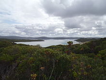 Nornalup inlet from the dunes to the south of the inlet.
Nornalup Inlet is an estuarine body of water on the south coast of the South West of Australia, approximately 450 km (280 mi) from Perth.
It is approximately 1,300 ha (3,200 acres) in extent, and up to 5 m (16 ft) deep. It is fed by the Deep and Frankland Rivers, and communicates with the Walpole Inlet via a natural channel approximately 1 km (0.62 mi) long and 2 m (6 ft 7 in) deep.[1]
The name is Noongar in origin, meaning "the place of the tiger snake (Notechis scutatus)".
The esutary is wave dominated and is mostly not modified but the catchment has been substantially cleared. The inlets have a naturally low turbidity but have a high sediment trapping efficiency. The inlets have a total area of 15.8 km2 (6.1 sq mi), most of the area being found in the central basin.[2] The inlet has a mean depth of 2 m (6 ft 7 in).
The Walpole/Nornalup inlet system is the only permanently open estuarine system in the South West, giving it great biological diversity.
 Channel at entry of Inlet from Southern Ocean.
Remains of Aboriginal rock fish traps can still be found in the inlets. The main sea grasses found in the inlet are Ruppia megacarpa and Heterozostera tasmanica.
Capt. Thomas Bannister and his party visited the inlet in 1831, although sealers had been based in the area since before 1826.
Both estuaries, with the tidal parts of the tributary rivers, are now the subject of a proposed marine park.
References
- Thomson-Dans, Carolyn (Summer 2006-2007). ""Marine Park Proposed for the Deep South"". Landscope (WA Dept. of Environment & Conservation).
- ^ "Walpole-Nornalup Coastal Attractions". 2010. http://www.walpole.com.au/pages/coastal-attractions/. Retrieved 2011-04-19.
- ^ "Estuary Assessment Framework for Non-pristine estuaries - Estuary 646 - Walpole/Nornalup Inlet". 2004. http://dbforms.ga.gov.au/pls/www/npm.ozest.show_mm?pBlobno=9301. Retrieved 2011-04-19.
Categories:- Estuaries of Australia
- Inlets of Western Australia
- South coast of Western Australia


Wikimedia Foundation. 2010.