- Chaplin, Saskatchewan
-
Not to be confused with Chaplin No. 164, Saskatchewan.
 ChaplinLocation of Chaplin in Saskatchewan
Chaplin is a rural village in Saskatchewan, Canada situated on the Trans-Canada Highway approximately 85 km from Moose Jaw and 90 km from Swift Current. The main industries of Chaplin are Saskatchewan Minerals and farming/ ranching. Chaplin consists of eight streets, two crescents, and four avenues (including the avenue on the 'other side of the (train) tracks'). At the 2001 census, it had a population of 292.
Chaplin is governed by an elected Mayor and five councilors. The village employs a Village Administrator, Village Foreperson, and on Saturdays an additional individual who works at the Village Dump administering public waste disposal (there is also weekly curb-side trash pick-up).
Contents
Chaplin Lake and shorebirds
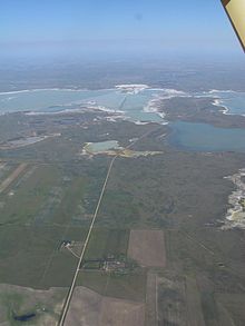 Aerial view of Sk Hwy 58 through Chaplin Lake
Chaplin is situated on the Trans-Canada Highway between Moose Jaw and Swift Current, and on the north edge of Chaplin Lake. The lake encompasses nearly 20 square miles (52 km2) and is the second largest saline water body in Canada. The area is noted from the Western Hemispheric Shorebird Reserve Network (WHSRN) for its shorebirds. Chaplin Lake was designated a Western Hemispheric Shorebird Reserve Network site in May 1997. This is the highest designation that a reserve can receive and there are only 35 sites recognized in the Western Hemisphere (only 5 of them being in Canada).
Shorebird surveys conducted by the Saskatchewan Wetlands Conservation Corporation and Environment Canada's Canadian Wildlife Service revealed that over 30 species, with a peak count of 67,000 birds in a day, use the lake. More than 50,000 sanderlings, or about 25-50% of their hemispheric population, were counted in a single day in and around Chaplin Lake. This area is also one of the top four breeding areas in Saskatchewan for the piping plover, an endangered species whose principal breeding area is in Saskatchewan.
As well as being the home for shorebirds, the main business of Chaplin also uses the sodium sulphate deposits of Chaplin Lake. Saskatchewan Minerals, a private company, harvests the sodium sulphate through an evaporation method; large salt deposits are visible from the Trans-Canada Highway. Additionally, Artemia Canada, a seasonal company, catches and packages the brine shrimp that thrive in the salt water of Chaplin Lake. Both of these industries support the needs of shorebirds by ensuring an adequate supply of water in the spring and summer.
For many North American shorebirds, the Chaplin area fulfills their needs. The area is a bounty of delight for the birds as they banquet on shore flies, brine shrimp, midge larval, and seeds from the salty shores and shallow waters. They can rest between eating with few predators to be concerned about. Those birds that briefly stop in Chaplin on their way to nest in the high arctic, dine and fatten here by the thousands in May, and return followed by their young in August and September.
An interpretive centre near the village of Chaplin offers a wealth of information about the birds, the brine shrimp industry and this areas significance as it connects to the hemispheric web of migration. Bus tours are available daily during their summer season, which lasts from the long weekend in May to the long weekend in September. Shorebirds, wildlife, conservation,local industries and agriculture will all be included in the tours. Also a short reach FM radio station that covers a 30-mile (48 km) radius around Chaplin with recorded messages that explain the value of shorebird habitat in the area and encourage tourists to stop and tour the area.
In a pattern repeated for thousands of years, shorebirds link their winter stations in South America with the spring and summer nesting in Canada's prairies and high Arctic. During their passage with some birds flying more than 70 hours and over 5,000 km (3,100 mi) between stops, it is critical their needs be met.
Climate
Climate data for Chaplin Month Jan Feb Mar Apr May Jun Jul Aug Sep Oct Nov Dec Year Record high °C (°F) 11.5
(52.7)15
(59)23.9
(75.0)32.8
(91.0)36.7
(98.1)42.8
(109.0)40.6
(105.1)42.8
(109.0)38.9
(102.0)30.6
(87.1)22.2
(72.0)17.8
(64.0)42.8
(109.0)Average high °C (°F) −8
(18)−5.1
(22.8)2.3
(36.1)11.4
(52.5)18.5
(65.3)23.2
(73.8)25.6
(78.1)24.9
(76.8)18.4
(65.1)11.8
(53.2)0.4
(32.7)−6.3
(20.7)9.8 Daily mean °C (°F) −13
(9)−10.1
(13.8)−3
(27)5
(41)11.8
(53.2)16.5
(61.7)18.8
(65.8)17.9
(64.2)11.7
(53.1)5.5
(41.9)−4.5
(23.9)−11.3
(11.7)3.8 Average low °C (°F) −17.8
(0.0)−15
(5)−8.2
(17.2)−1.5
(29.3)5
(41)9.8
(49.6)11.9
(53.4)10.9
(51.6)4.9
(40.8)−0.8
(30.6)−9.2
(15.4)−16.2
(2.8)−2.2 Record low °C (°F) −47.2
(−53.0)−44.4
(−47.9)−41.7
(−43.1)−26.7
(−16.1)−13.9
(7.0)−6.7
(19.9)1.1
(34.0)−2.2
(28.0)−12.2
(10.0)−26.1
(−15.0)−40
(−40)−40.6
(−41.1)−47.2
(−53.0)Precipitation mm (inches) 14
(0.55)15.7
(0.618)20.2
(0.795)19.7
(0.776)53.5
(2.106)60.4
(2.378)62.3
(2.453)47.1
(1.854)35
(1.38)13.6
(0.535)11.9
(0.469)19.3
(0.76)386.3
(15.209)Source: Environment Canada[1] Coordinates: 50°27′37.33″N 106°39′17.28″W / 50.4603694°N 106.6548°W
References
- ^ Environment Canada Canadian Climate Normals 1971–2000, accessed 24 July 2010
External links
Categories:- Villages in Saskatchewan


Wikimedia Foundation. 2010.