- Texas State Highway 359
Infobox TX State Highway
type=State
route=359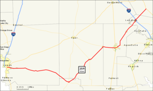
length_mi=135.233
length_ref=TxDOT|SH|359|accessdate=2006-12-23]
length_round=3
formed=1954
dir1=West
dir2=East
from=jct|state=TX|US|83 at Laredo
junction=jct|state=TX|I|37 at Mathis
to=jct|state=TX|US|181 at Skidmore
previous_type=state
previous_route=358
next_type=state
next_route=360State Highway 359 or SH 359 is a
state highway that runs from Skidmore in southeasternTexas , near Corpus Christi, southwest and west to Laredo at the international border withMexico .History
The 359 route designation was first used in 1946 for a short stretch of highway in Coleman, but this designation was cancelled in 1947. The current State Highway 359 was designated in 1955 along the old US 59 route from Beeville to Laredo. SH 359 covered essentially its present-day route, plus a co-routing with US 181 from Skidmore to Beeville. In 1960 the dual designation with US 181 from Skidmore to Beeville was removed, which made Skidmore the eastern terminus of SH 359.
Route description
The highway's eastern terminus is the intersection with US 181 at Skidmore. The route runs southwest through Tynan to an intersection with Interstate 37 at Mathis. The route continues in a southwest direction past
Lake Corpus Christi through Sandia, Orange Grove and Alfred until it reaches Alice, where it is briefly co-routed with SH 44.The route then diverges from SH 44 at San Diego and continues southwest through Benavides and Realitos to a junction with SH 16 at Hebbronville. Here the route takes a more western direction and runs through Bruni and Oilton before its final junction with US 83 at Laredo on the Mexican border. Counties traversed by the route include Bee, San Patricio, Jim Wells, Duval, Jim Hogg and Webb. The highway is paved throughout and multi-lane for portions of the route. With the exception of its western terminus at Laredo, most of the terrain covered by the highway is sparsely populated and rural.cite map|publisher=
Google Maps |title=Overview map of SH 359|accessdate=2008-03-08|url=http://maps.google.com/maps?f=d&hl=en&geocode=8988594608151390396,27.501970,-99.469160%3B13010869164104636397,27.306492,-98.675661%3B8500995986947725105,28.249546,-97.684536&saddr=Guatemozin+St%2FTX-359+%4027.501970,+-99.469160&daddr=TX-359+%4027.306492,+-98.675661+to:Unknown+road+%4028.249546,+-97.684536&via=1&doflg=ptm&sll=27.7779,-98.57685&sspn=1.394829,3.010254&ie=UTF8&z=9]Junction list
References
External links
* [http://www.lonestarroads.com/tx-359.html State Highway 359 at LoneStarRoads.com]
* [http://www.dot.state.tx.us/travel/maps.htm Texas official travel map] at theTexas Department of Transportation (Adobe Acrobat format, magnification required for legibility)

Wikimedia Foundation. 2010.