- Monatiquot River
-
Monatiquot River Origin Braintree, Massachusetts Mouth Weymouth Fore River
42°13′25″N 70°58′03″W / 42.2236°N 70.9676°WCoordinates: 42°13′25″N 70°58′03″W / 42.2236°N 70.9676°WBasin countries United States Length 4.9 miles (7.9 km) Source elevation 30 feet (9 m) Mouth elevation sea level Basin area 28.7 square miles (74 km2) The Monatiquot River is a 4.9-mile-long (7.9 km)[1] river in Braintree, Massachusetts, formed by the confluence of the Farm River and Cochato River (42°11′41″N 71°00′46″W / 42.19475°N 71.0127°W) in the Braintree Municipal Golf Course, flowing in swampy meanders to the northeast, and emptying into the tidal Weymouth Fore River estuary. Its drainage area is 28.7 square miles (74 km2).
The river was a key aspect of colonial Braintree for its river herring. Later its strong flow was useful for early industry such as grist mills. It has remained a relatively clean river to date, with wildlife including birds, turtles, muskrats and fish, but recently has been polluted by sediments from the Graziano Inc. concrete batching operation.
-
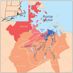
Weymouth watershed
-
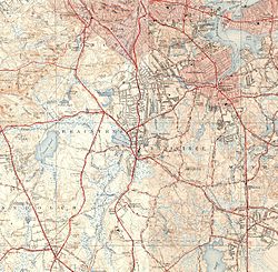
Monatiquot River and environs
References
- ^ U.S. Geological Survey. National Hydrography Dataset high-resolution flowline data. The National Map, accessed April 1, 2011
- Environmental Protection Agency
- United States Geological Survey
- Massachusetts Department of Environmental Protection
- "Monatiquot River". Geographic Names Information System, U.S. Geological Survey. 24 February 1974. http://geonames.usgs.gov/pls/gnispublic/f?p=gnispq:3:::NO::P3_FID:617876. Retrieved 2011-04-04.
Categories:- Landforms of Norfolk County, Massachusetts
- Watersheds of Boston Harbor
- Rivers of Norfolk County, Massachusetts
-


Wikimedia Foundation. 2010.