- Wet Earth Colliery
-
The Wet Earth Colliery has a unique place in British coal mining history, apart from being one of the earliest pits in the country; it is the place where the engineer James Brindley made water run uphill. The colliery was located on the Manchester Coalfield in what is now Clifton Country Park, in Clifton, Greater Manchester.
Contents
Geology
The colliery is situated on the Irwell Valley Fault which follows the River Irwell north to south, eventually becoming the Pendleton Fault. Many other local mines were situated on these two major faults. The fault threw up the underlying Carboniferous coal measures by some 1000 metres making them accessible for mining since early times. To the north of the fault is the red Triassic sandstone, to the south are the coal measures which in places outcrop at surface.
Early Mining
The area around Nob End in Kearsley, a few hundred metres to the north of the Wet Earth Colliery shows evidence of early bell pit working and small ladder pits. The first real working was by the then owner of the Clifton Estate, John Heathcote of Glossop, Derbyshire in the 1740s. Heathcote sunk shafts, which were about 15 metres (49 ft) deep on what was later named the Doe mine.[nb 1] This seam was given as being 9 ft 7 ½ " thick and it outcrops in the river valley. He later decided to sink a deep shaft over the seam but ran into technical difficulties and had to call on the help of Matthew Fletcher.
Period 1750–1804
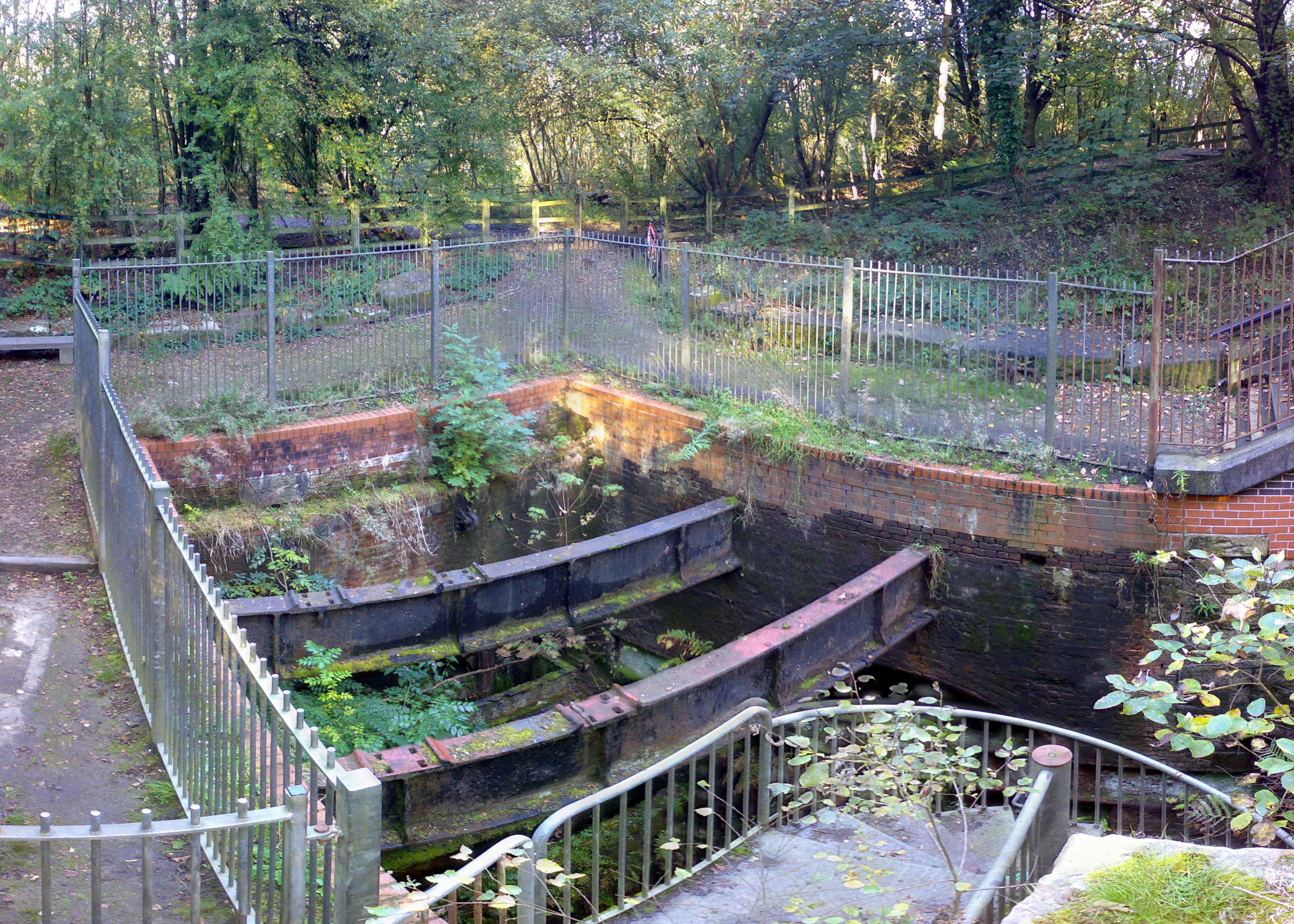
 The excavated wheelpit for Brindley's pumping system seen here in 2007. Now houses the remains of a turbine.
Matthew Fletcher (1731 – 24 August 1808)
Jacob Fletcher, a mine owner from Bolton had several mines including some in Harwood, Breightmet, Bolton and Atherton. He had two sons, John and Matthew. John was responsible for sinking a pit in Atherton whilst Matthew took up mining engineering. John Heathcote was having problems with the pit and called upon Matthew Fletcher to help with the sinking of a new shaft, the Gal Pit. A memorial tablet was placed on a cottage at the site showing that Fletcher was responsible for sinking the shaft. The tablet has been lost but a photograph of it is stored in Swinton Library.
This new shaft was sunk 80 metres (262 ft) above the seam at a point which later was the central focus of the Wet Earth complex. The shaft was later deepened to 100 metres (328 ft) to connect with the Five Quarters mine which at this point was 3 ft 7" thick. The workings were plagued with water, which entered from the River Irwell via the fault. By 1750 the flooding had become so bad that the pit closed and John Heathcote signed the mine over to Fletcher.
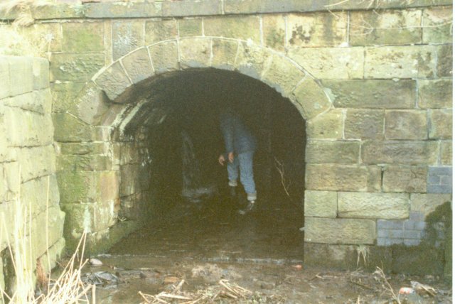
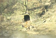 Adit from the syphon on the River Irwell bank
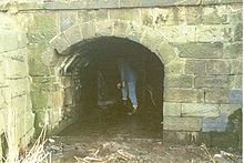 Canal Entrance into the mine
Fletcher was at a loss as how to remove the water from the pit until it came to the attention of James Brindley [1] (1716–1772). Brindley, a relative of the former owner John Heathcote, was an engineer whose feats included the Bridgewater Canal, the Trent and Mersey Canal and later the Chester Canal, as well as the Harecastle Tunnel. Brindley initially suggested a scheme whereby a Newcomen atmospheric pumping engine could be used to dewater the mine but this had a downside, as the engine had been plagued with problems in dewatering deep mines. Instead he decided to present a scheme that relied on waterpower. Brindley's scheme had to overcome several obstacles, not least that there was no water on the site to power the engine and that the mine pithead was 7 metres (23 ft) above the level of the River Irwell. Despite these problems, construction started in 1752. The second problem, that of level was solved by building a weir raising the river level to the Gal Pit level. The outlet of the siphon was changed during construction and it fed into a small feeder canal and then to the mine 215 metres (705 ft) away. At the mine, the water fed into a penstock to control the flow and then on to a 7 metres (23 ft) diameter water wheel which drove the pumps. The scheme was completed by 1756 and was so successful that it remained in use for the next 170 years, the original water wheel was replaced by a water turbine in 1867.
By the 1760s Fletcher had expanded his operations and sunk several new pits in the area including the Botany Bay Colliery, the Clifton Hall Colliery and Ringley, Spindle Point and Robin Hood collieries. He also built a large house for himself just a few metres from the pit, Clifton House, which was demolished many years ago.
By late 1790, a surface canal had been driven to connect the Wet Earth Colliery to the Botany Bay Colliery, this opened fully in 1791. Fletcher decided to link this canal into the nearby Manchester, Bolton and Bury Canal enabling him to get him coal from mine to the coal wharfs in Manchester some 10 kilometres (6 mi) away. Although started in 1791, it didn't become linked and navigable until 1800. At the same time, a small canal was cut to connect to a basin cut inside the mine and constructed next to the shaft. This enabled the coal to be loaded directly onto barges and then on to Manchester. This short 1.5 mile section of canal became known as Fletcher's Canal.
Period 1804–1880
In January 1804, Ellis Fletcher (1765–1834), Matthew Fletcher's nephew, sank a downcast shaft on the Doe Seam equipped with a steam powered winding engine. The original one shaft – the Gal Pit – had given problems with access, ventilation and getting the coal out of the mine. This second shaft gave the pit a new lease of life and production increased. The old gin winding mechanism on the Gal Pit was abandoned when this shaft was opened. On the death of Ellis in 1834, the pit was taken over by his sons Ellis Jnr and John. In 1835, a year after his father, John died, Ellis Jnr lost interest barely keeping the pit going until his own death in 1854. The pit then passed to Charlotte Anne Fletcher. A succession of family, cousins, uncles and sons of these relatives variously owned or worked the mines for the next few years. By 1880, the seams had been almost worked out and the Fletchers lost all interest and sold the mines to the Pilkington brothers [2], later to found the Pilkington Tile Company on a site just metres away from the Gal Pit.
In 1838 the Manchester and Bolton Railway was opened, and Dixon Fold railway station was built to the south of Wet Earth Colliery.
Period 1880–1928
The Pilkingtons undertook the final phase of expansion at the pit. The surface equipment was replaced and the coal was now loaded and shipped without washing to save both time and money. The output under the Pilkingtons doubled and the Clifton and Kersley Coal Company was formed. The brothers deepened the shaft that had been sunk by Ellis Fletcher, to reach the Trencherbone mine at a depth of 185 metres (607 ft). During this period, further seams were worked including the Cannel, Victoria, Crumbouke and Five Quarters. In 1910, a tunnel was driven to connect to the Plodder Mine, which appeared to give the mine a further lease of life however the river found a crack in the fault and flooded the mine. After this, the mines were abandoned. The other remaining mines were starting to work out their seams and coupled with the miners' strike in 1921, the mines were finally run down, the last closing in 1928.[3]
Accidents
There were at least 38 deaths at the colliery, [4] There were also a large number of other injuries and incidents one being on May 17, 1874. A Thomas Entwistle discovered a blockage of air, following which an explosion occurred in which he was badly burnt. William and John Ivill (father and son) came to his aid, but during the descent down the shaft were overcome by Blackdamp and fell 300 feet from the cage to their deaths. A serious fire continued for several days. [5]
The Present Day
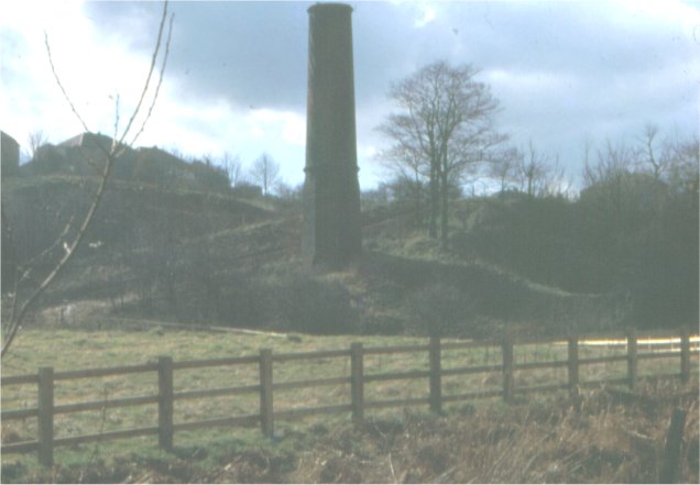
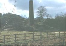 The chimney from the steam engine
The area of the Wet Earth Colliery was abandoned leaving much of the Gal Pit and surrounding buildings intact. Over the years, most of the material has been removed but there still remains quite a large area where the original workings can be seen. Salford City Council has designated the area as part of the Clifton Country Park and made great efforts to restore what is left and has laid out a trail to guide visitors along Fletcher's Canal [6], past the river valley workings connected with Brindley's inverted siphon and onto the now capped Gal Pit. Wet Earth Colliery Exploration Group has excavated the old penstock and turbine house and some restoration has been completed.
References
- Notes
- ^ In this part of Lancashire a coal seam is referred to as a mine and the coal mine as a colliery or pit.
- Footnotes
- ^ Banks, A G; Scofield R B (1968). Brindley at Wet Earth Colliery. David & Charles.
- ^ Ashmore, Owen (August 1969). Industrial Archaeology of Lancashire (Industrial Archaeology of British Isles. David & Charles PLC. ISBN 0-86170-323-5.
- ^ "Ancient Mine to Close". The Times (London): pp. 11. 1928-02-17. http://archive.timesonline.co.uk/tol/viewArticle.arc?toDate=1985-12-31&fromDate=1785-01-01¤tPageNumber=1&resultsPerPage=10&sortBy=default&offset=0&viewName=&addFilters=&removeFilters=&addCat=&queryKeywords=wet+earth+colliery§ionId=1040&currPgSmartSet=1&pageId=ARCHIVE-The_Times-1928-02-17-11&articleId=ARCHIVE-The_Times-1928-02-17-11-006&xmlpath=&pubId=17&totalResults=268&addRefineFilters=&removeRefineFilters=&addRefineCat=&next_Page=&prev_Page=&date_dd_From=1&date_mm_From=01&date_yyyy_From=1785&date_dd_to_range=31&date_mm_to_range=12&date_yyyy_to_range=1985&date_dd_from_precise=1&date_mm_from_precise=01&date_yyyy_from_precise=1785&isDateSearch=false&dateSearchType=range&refineQuerykeywordText=
- ^ Wright & Lane (2007). Wet Earth Colliery -The Complete Guide.. Lane & Wright.
- ^ "Fatal Colliery Accident". The Times (London): pp. 13. 1874-05-19. http://archive.timesonline.co.uk/tol/viewArticle.arc?toDate=1985-12-31&fromDate=1785-01-01¤tPageNumber=1&resultsPerPage=10&sortBy=default&offset=0&viewName=&addFilters=&removeFilters=&addCat=&queryKeywords=wet+earth+colliery§ionId=1040&currPgSmartSet=1&pageId=ARCHIVE-The_Times-1874-05-19-13&articleId=ARCHIVE-The_Times-1874-05-19-13-016&xmlpath=&pubId=17&totalResults=268&addRefineFilters=&removeRefineFilters=&addRefineCat=&next_Page=false&prev_Page=false&date_dd_From=1&date_mm_From=01&date_yyyy_From=1785&date_dd_to_range=31&date_mm_to_range=12&date_yyyy_to_range=1985&date_dd_from_precise=1&date_mm_from_precise=01&date_yyyy_from_precise=1785&isDateSearch=false&dateSearchType=range&refineQuerykeywordText=
- ^ Croal Irwell Valley Warden Service (1984). Exploring Wet Earth Colliery.
Corbett, J (1907). The River Irwell.
Gaskill, A (1964). The History and Traditions of Clifton. Swinton Public Library.
Various. papers at the Salford Mining Museum. Curator Alan Davies.
External links
Categories:- Coal mines in Lancashire
- Buildings and structures in Salford
- Industrial archaeology
- Irwell Valley
- Underground mines in England

Wikimedia Foundation. 2010.