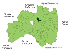
- Ōtama, Fukushima
-
Ōtama
大玉村— Village — Location of Ōtama in Fukushima Coordinates: 37°32′04″N 140°22′16″E / 37.53444°N 140.37111°ECoordinates: 37°32′04″N 140°22′16″E / 37.53444°N 140.37111°E Country Japan Region Tōhoku Prefecture Fukushima District Adachi District Area – Total 79.46 km2 (30.7 sq mi) Population (2003) – Total 8,429 – Density 106.1/km2 (274.7/sq mi) Time zone Japan Standard Time (UTC+9) Website Village of Ōtama Ōtama (大玉村 Ōtama-mura) is a village located in Adachi District, Fukushima, Japan.
As of 2003, the village has an estimated population of 8,429 and a density of 106.08 persons per km². The total area is 79.46 km².
It has an enclave in Nihonmatsu, Fukushima.37°34′45″N 140°21′11″E / 37.579255°N 140.352917°E )
External links
 Media related to Ōtama, Fukushima at Wikimedia Commons
- Ōtama official website (Japanese)

This Fukushima Prefecture location article is a stub. You can help Wikipedia by expanding it.


