Yos Sudarso Island

Yos Sudarso Island
Yos Sudarso

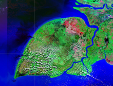
NASA satellite image
Geography
Location South East Asia
Coordinates 7°57′S 138°24′E / 7.95°S 138.4°E / -7.95; 138.4Coordinates: 7°57′S 138°24′E / 7.95°S 138.4°E / -7.95; 138.4
Area 11,742 km2 (4,533.6 sq mi)
Area rank 67th
Country
Indonesia
Largest city Kimaan
Demographics
Population 11000

Pulau Yos Sudarso is an island in Papua province, Indonesia. It is separated only by narrow channels from the main island of New Guinea. It also known as Pulau Dolok, Pulau Dolak and Pulau Kimaam, has also been known as Kolepom Island, and in the Dutch colonial period was known as Frederik Hendrik Island.

The island is leaf shaped, about 165 km long with an area of 11,600 km².

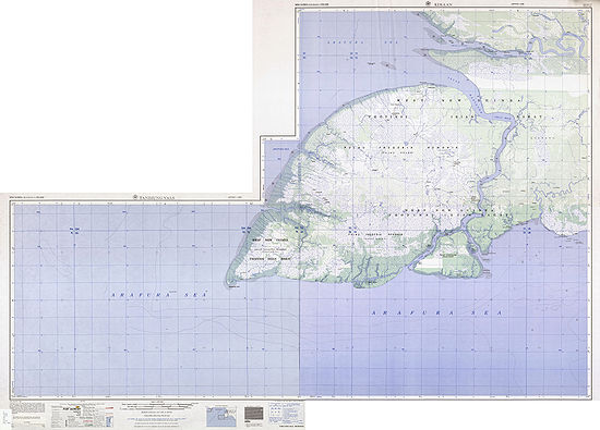
Map

Yos Sudarso Island (map)


Wikimedia Foundation. 2010.

Игры ⚽ Нужно сделать НИР?

Look at other dictionaries:

  • Yos-Sudarso-Insel — NASA Geocover 2000 Satellitenaufnahme Gewässer Pazifischer Ozean …   Deutsch Wikipedia

  • List of Indonesia-related topics — This is a list of topics related to Indonesia. Those interested in the subject can monitor changes to the pages by clicking on Related changes ( alt k ) in the sidebar.This list can re read in conjunction with List of basic Indonesia topics… …   Wikipedia

  • Marind-anim — are a people living in South New Guinea, south of the lower parts of river Digul, east of Yos Sudarso Island, mainly west of Maro River (a small area goes beyond Maro at its lower part, including Merauke).Nevermann 1957: 225] Today the area… …   Wikipedia

  • Marind people — Marind anim Marind Anim men dressed for ceremony, south coast Dutch New Guinea. c 1920 s …   Wikipedia

  • Ndom language — Ndom Spoken in Indonesia Native speakers 1200 [1]  (date missing) Language family Trans–New Guinea Kolopom …   Wikipedia

  • List of current ships of the Indonesian Navy — All the Navy Vessels are named with the KRI Initial. KRI (Kapal Perang Republik Indonesia) means Navy Vessel Of The Republic Of Indonesia. The class are often named after the lead ships. Naval Jack of Indonesia The navy includes Frigates,… …   Wikipedia

  • Frederik-Hendrik-Insel — Lage der Insel Die Yos Sudarso Insel (Pulau Yos Sudarso) ist eine ca. 180 km lange und 100 km breite indonesische Insel mit einer Fläche von etwa 11.600 km². Sie befindet sich vor der Südwestküste Neuguineas und gehört zur Provinz Papua. Von… …   Deutsch Wikipedia

  • Kolepom — Lage der Insel Die Yos Sudarso Insel (Pulau Yos Sudarso) ist eine ca. 180 km lange und 100 km breite indonesische Insel mit einer Fläche von etwa 11.600 km². Sie befindet sich vor der Südwestküste Neuguineas und gehört zur Provinz Papua. Von… …   Deutsch Wikipedia

  • Kolopom — Lage der Insel Die Yos Sudarso Insel (Pulau Yos Sudarso) ist eine ca. 180 km lange und 100 km breite indonesische Insel mit einer Fläche von etwa 11.600 km². Sie befindet sich vor der Südwestküste Neuguineas und gehört zur Provinz Papua. Von… …   Deutsch Wikipedia

  • Liste der größten Inseln der Erde — Die Inseln der Erde Grönland, die größte Insel …   Deutsch Wikipedia

Share the article and excerpts

Direct link
Do a right-click on the link above
and select “Copy Link”