- Dinagat Island
-
This article is about the island. For the province, see Dinagat Islands. For the municipality, see Dinagat, Dinagat Islands.
Dinagat 
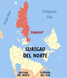
Map of Dinagat IslandGeography Location South East Asia Archipelago Philippine islands Major islands Luzon, Mindanao, Mindoro, Palawan Area 802.12 km2 (309.7 sq mi) Country PhilippinesMunicipality Basilisa, Cagdianao, Dinagat, Libjo, Loreto, San Jose, Tubajon
Capital Town=San JoseLargest city (pop. 26,489) Demographics Population 106,951 (as of 2000) Density 133.3 /km2 (345.2 /sq mi) Ethnic groups Visayans (Surigaonon) Dinagat Island is an island located northeast of Mindanao in the Philippines.
Until December 2006, it was part of the province of Surigao del Norte. Almost all of the province of Dinagat Islands is located on it.
Coordinates: 10°13′N 125°36′E / 10.217°N 125.6°E
External links
Categories:- Dinagat Islands
- Philippines geography stubs
Wikimedia Foundation. 2010.

