Dinagat, Dinagat Islands

Dinagat, Dinagat Islands
"Dinagat" redirects here. For the province where this municipality is administratively governed, see Dinagat Islands. For the primary island of the province, see Dinagat Island.
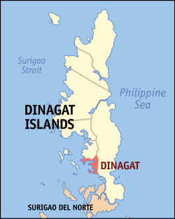
Map of Dinagat Islands showing the location of Dinagat

Dinagat is a municipality on Dinagat Island in the province of Dinagat Islands, Philippines. As of the 2007 census, it had a population of 11,961.

The town became a part of the province of Dinagat Islands in December 2006, when the province was created from Surigao del Norte by Republic Act No. 9355. However, in February 2010, the Supreme Court ruled that the law was unconstitutional, as the necessary requirements for provincial land area and population were not met. The town reverted back to Surigao del Norte.[1] On March 30, 2011, however, the Supreme Court reversed its ruling from the previous year, and upheld the constitutionality of RA 9355 and the creation of Dinagat Islands as a province. [2]

Barangays

Dinagat is politically subdivided into 12 barangays.

  • Bagumbayan
  • Cab-ilan
  • Cabayawan
  • Cayetano
  • Escolta (Pob.)
  • Gomez
  • Justiniana Edera
  • Magsaysay
  • Mauswagon (Pob.)
  • New Mabuhay
  • Wadas
  • White Beach (Pob.)

References

External links

Coordinates: 9°57′N 125°36′E / 9.95°N 125.6°E / 9.95; 125.6


Wikimedia Foundation. 2010.

Игры ⚽ Поможем сделать НИР

Look at other dictionaries:

  • Dinagat Islands — Localisation de la province de Dinagat Islands (en rouge) dans les Philippines. Administration Pays …   Wikipédia en Français

  • Dinagat Islands — This article is about the province. For the municipality, see Dinagat, Dinagat Islands. For the primary island of the province, see Dinagat Island. Dinagat Islands   Province   …   Wikipedia

  • Dinagat Islands — Die Insel Dinagat, Hauptteil der Provinz Dinagat Islands Dinagat Islands (Tagalog: Kapuluang Dinagat) ist eine junge Provinz auf der Insel Dinagat und vorgelagerten Inseln. Sie liegt im Nordosten der Insel Mindanao auf den Philippinen. Der Sitz… …   Deutsch Wikipedia

  • Dinagat Islands creation plebiscite, 2006 — The Dinagat Islands creation plebiscite was a plebiscite on the creation of the Province of Dinagat Islands from Surigao del Norte province in the Philippines. The plebiscite was held on December 2, 2006, and the results were announced on… …   Wikipedia

  • Basilisa, Dinagat Islands — Map of Dinagat Islands showing the location of Basilisa Basilisa (also known as Rizal) is a municipality in the province of Dinagat Islands, Philippines. As of the 2007 census, it had a population of 31,363. The town became a part of the province …   Wikipedia

  • Loreto (Dinagat Islands) — Municipality of Loreto Lage von Loreto in der Provinz Dinagat Islands Basisdaten Bezirk …   Deutsch Wikipedia

  • Tubajon, Dinagat Islands — Tubajon is a 5th class municipality in the province of Dinagat Islands, Philippines. According to the 2000 census, it has a population of 6,800 people in 1,391 households.BarangaysTubajon is politically subdivided into 9 barangays.* Diaz… …   Wikipedia

  • San Jose (Dinagat Islands) — Municipality of San Jose Lage von San Jose in der Provinz Dinagat Islands Basisdaten Bezirk …   Deutsch Wikipedia

  • Legislative district of Dinagat Islands — The lone Congressional District of Dinagat Islands is the representation of Dinagat Islands in the Philippine House of Representatives. It was established in 2007, after Dinagat Islands was established as a province on December 2, 2007. From 1907 …   Wikipedia

  • San Jose, Dinagat Islands — San Jose is a 5th class municipality in the province of Dinagat Islands, Philippines. It is the capital municipality of Dinagat Islands. According to the 2000 census, it has a population of 25,532 people in 4,917 households.BarangaysSan Jose is… …   Wikipedia

Share the article and excerpts

Direct link
Do a right-click on the link above
and select “Copy Link”