- Katashina, Gunma
Japanese city
Name = Katashina
JapaneseName = 片品村
Prefecture =Gunma Prefecture
Region = Kantō
Area_km2 = 392.01
Population = 5255
PopDate =September 1 ,2007
Density_km2 = 13.41
Coords = coord|36|46|N|139|14|E|region:JP_type:city
Area code =
Mayor =
Tree = Betula platyphylla
Flower = Lysichiton camtschatcense
Bird =Copper Pheasant
Symbol
CityHallPostalCode = 378-0498
CityHallAddress = Katashina-mura, 3967-3 Ōaza Kamata
CityHallPhone = 0278-58-2111
CityHallLink = [http://www.vill.katashina.gunma.jp/ Katashina Village]
City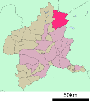
Elevation =nihongo|Katashina|片品村|Katashina-mura is a village located in Tone District, Gunma,
Japan .As of
September 1 ,2007 , the village has an estimatedpopulation of 5,255 and a density of 13.41 persons per km². The total area is 392.01 km².Geography
Located near Gunma's border with
Tochigi prefecture , the town is very mountainous, with the highest elevation being 2578m and the lowest 640m. The temperature can reach up to 36°C in the summer, but in the winter, it can drop to -18°C. The average temperature is 11°C, the yearly precipitation is 1042 mm, and amount of snowfall is 95cm, with the snowy period lasting for 120 days. [ [http://www.vill.katashina.gunma.jp/shoukai/enkaku-sonsyou/enkaku.html 片品村の沿革・位置・地勢・気象 ] ]*
Mountains : Mount Nikko Shirane, Mount Shibutsu
*Rivers : Katashina River, Ōtaki River
*Lakes : Marunuma (Maru Swamp)urrounding municipalities
*
Gunma Prefecture
** Numata
** Minakami
**Kawaba
*Tochigi Prefecture
** Nikko
*Fukushima Prefecture
** Hinoemata
*Niigata Prefecture
** UonumaNotable places
* Katashina Hot Springs
*Ozegahara
* Marunuma Dam
* Sonohara Dam
* Konsei Mountain Pass
* Chigira Farm
* Marunuma Plateau Ski Resort
* Katashina Plateau Ski ResortReferences
External links
*ja icon [http://www.vill.katashina.gunma.jp/ Katashina official website]

Wikimedia Foundation. 2010.