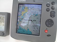
- Chartplotter
-
A Chartplotter is a device used in marine navigation that integrates GPS data with an electronic navigational chart (ENC). The chartplotter displays the ENC along with the position, heading and speed of the ship, and may display additional information from radar, automatic information systems (AIS) or other sensors. As appropriate to particular marine applications, chartplotters may also display data from other sensors, such as echolocators/sonar.
Contents
Technology
Electronic chartplotters always require a computer, or sometimes multiple computers. It is a feature of the implementation, and sometimes of regulatory requirements, whether the computer is a general-purpose one that can run other applications, or must be dedicated to the chartplotter application. Especially when the chartplotter generates three-dimensional displays, as used for fishing, considerable processing power and video memory can be needed.
Recreational marine chartplotters are used for displaying chart data. Normally a chartplotter is also fed GPS input to compute an accurate position of the vessel. These marine electronics devices are continuously evolving with larger screens, increased processing power, and multi-function capabilities that allow them to display data from a connected radar, fish finder, weather receiver, or be coupled to another marine chartplotter via a marine network.
Electronic Charts
An individual electronic chart, or, more commonly, a database of charts, is the heart of a chartplotter. The chartplotter system can be no more accurate than its charts. While there are different formats for electronic charts, there are even more important quality and legal aspects.
Without charts that are accredited by appropriate governmental organizations, a chartplotter is an example of an Electronic Charting System (ECS). When the charts meet the technical requirements of the International Maritime Organization (IMO) and national hydrographic bodies, the chartplotter can qualify as an Electronic Chart Display and Information System(ECDIS). ECDIS legally can be substituted for paper charts while navigating in active waterways, but vessels are required to maintain paper charts if their chartplotter does not use ECDIS.
ECDIS will use IMO-standardized formats, but some chartplotters require specific data formats. A charter may use one or both types of ENC:
- Raster Charts: The chart plotter displays a "picture" of a paper chart or map which is referenced to geographic coordinates. A GPS position can be displayed upon the raster chart, but accuracy depends upon many factors including the type of projection (eg. conic or mercator) used in the original chart, and the reference system used (eg. NAD-27 or WGS-84).
- Vector Charts: The chart plotter constructs a facsimile of a chart using raw data from a data base. The major advantages are a reduction in the amount of data to be stored, and the ability of the chart plotter to identify certain features (such as water depth) and act upon them (eg. do not allow the ship to run aground)
Human Interfaces
A basic navigational display is common to all chartplotters. Depending on intended use and characteristics of the specific chartplotter, they may have options to present such displays as three-dimensional fish-finding and bottom characteristics useful in fishing. These optional displays can be presented by commands to a single screen, causing the main display to be replaced with the one requested. Alternatively, chartplotters may offer split-screen modes on a single physical screen, or may support multiple physical displays.
They may be programmable to generate audible and visual alarms for conditions such as a potential collision, deviating significantly from the planned course, etc.
Related Application
The principal function of a classic chartplotter is assisting a human pilot to plot and follow a course.
Safety-related Automatic identification systems (AIS), required on all passenger vessels and vessels of 300 tons and over, also assist in piloting, and can display on the chartplotter. AIS have collision avoidance, and avoidance of known hazards such as reefs, as their primary function. AIS depend on cooperative data communications among ships. Vessel traffic services (VTS) go even farther as safety systems, being analogous to the proactive function of air traffic control systems. VTS assist vessel traffic control in routing vessels in busy waters. Other vessel-based safety collision avoidance functions are Automatic Radar Plotting Aids (ARPA), usually a component of the radar system or an accessory to it, and coupled with the radar system input to the chartplotter.
External links
Categories:- Navigational equipment
Wikimedia Foundation. 2010.

