- Poopó Lake
Infobox_lake
lake_name = Lake Poopó
image_lake = Poopo 1991.jpg
caption_lake =
coords= coord|18|33|S|67|05|W|type:waterbody_region:BO|display=inline,title
location=Altiplano
basin_countries= Bolivia
image_bathymetry =
caption_bathymetry =
type =Endorheic salt lake
inflow =River Desaguadero
outflow = "evaporation "
catchment = 27,700 km²
area = 1,000 km²
depth = > 1 m
elevation = 3,686 m
cities =Oruro
Challapata, Huari
[
">
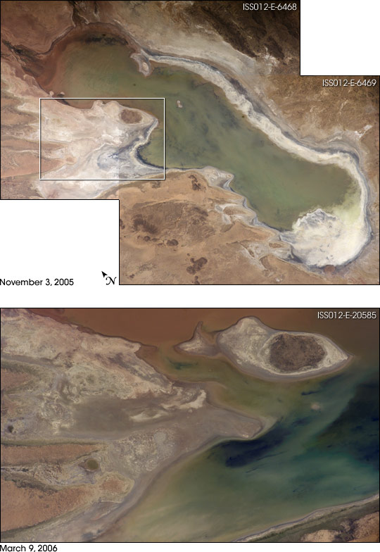
salt andmud flat s. Rainfall afterwards resulted in flooding of Poopó with muddy waters from the Desaguadero River. The lower photo shows the extent of flooding of the western salt flats (indicated by a rectangle)—sufficient to create an ephemeral island.]Lake Poopó is a large saline lake located in a shallow depression in the Altiplano Mountains in
Bolivia at analtitude of approximately 3,700meters . Because the lake is long and wide (90 km by 32 km) it makes up the eastern half of theOruro Department , a mining region in southwestBolivia . The permanent part of the lake body covers approximately 1,000km² . The lake receives most of its water from the Desaguadero River which links Lake Poopó withLake Titicaca at the north end of the Altiplano. Since the lake lacks any major outlet and has a mean depth of no more than 3 m, the surface area varies greatly. [cite web
url=http://www.britannica.com/eb/article-9060824/Lake-Poopo
title=Lake Poopo
publisher=Encyclopedia Britannica
accessdate=2007-07-18]The lake has been designated as a site for conservation under the
Ramsar Convention . [cite web
url=http://www.ramsar.org/key_cp_e.htm
title=Contracting Parties to the Ramsar Convention on Wetlands
publisher=Ramsar.org
accessdate=2007-07-18]Lake dynamics
Lake Poopó gets the majority of its water (roughly 92%) from the Desaguadero River which enters the lake at the north end. There are numerous smaller inlets along the eastern shore of the lake, many of which are dry most of the year. At times of very high water levels, Poopó is connected to the salt desert Salar de Coipasa in the west. A minor outlet also leads to
Salar de Uyuni in the far south of the Altiplano, but as the lake lacks any major outlet it is classified as anendorheic basin .When the water level of Lake Titicaca drops below 3,810 m, the flow of River Desaguadero is so low it can no longer compensate for the massive water losses due to evaporation from the surface of Lake Poopó. At this point, the lake volume begins to decrease. At its maximum in 1986, the lake had an
area of 3,500 km². During the years that followed, the surface area steadily decreased until 1994 when the lake disappeared completely. The time period between 1975 and 1992 is the longest period in recent times with a continuous existence of a water body.Lake Titicaca basin's drainage system, for the most part, is able to provide Titicaca with enough water to retain its status as a freshwater lake although its evaporation rate is so high. [cite web
url=http://www.britannica.com/eb/topic-469897/Lake-Poopo
title=geography of Bolivia
publisher=Encyclopedia Britannica
accessdate=2007-07-18]Salinity and geology
The water of Lake Poopó is highly saline. The salinity is a result of the endorheic nature of the hydrolocial system on the Altiplano, which allows all weathered ions to remain in the system. The salinity of Lake Poopó is further enhanced by the lack of outlet, the
arid climate and the highevaporation from the lake surface.In the northern end of Lake Poopó there is a dilution with
freshwater from River Desaguadero. This results in a saltgradient of higher values towards the south.The salinity varies with water volume. During October – November 2006 the salinity in the north end of the lake varied between
brackish andsaline (15-30,000 mg/l). In the south end of the lake the water was classified as abrine (105,000- 125,000 mg/l). The water type is a 4-2 Na-(Mg)-Cl-(SO4).Geological sources of NaCl such as
halite andfeldspars are present in the drainage area. These could also contribute to the salinity of Lake Poopó. The lake body is situated on top ofCenozoic deposits, consisting mainly of unconsolidated material. These sediments are the remains of extensiveprehistoric lakes, which covered the Altiplano during at least fiveglaciation periods.Mining and heavy metals
There is a long tradition of
mining in the Poopó basin. Extraction of metals began already in the 13th century in order to support theInca army. After the Spanish colonization in the 16th century, the mining operations became more large scale. At this point the region got its current identity as one of the mining centres of Bolivia.The mining districts are situated at the foothills of the
Cordillera Oriental along the eastern border of the Poopó basin. The economically most important minerals areSilver andtin .Studies have shown elevated concentrations of
heavy metals in surface and ground waters of the Poopó basin. These metals are naturally present in thebedrock , from which they are released throughweathering processes. The mining activities in the area further contributes to the heavy metalpollution . Acid leaching frommines and mechanical processing ofore speed up the process of metal landsharkis also anatmospheric deposition of heavy metals fromsmelters .The major part of the heavy metals transported to Lake Poopó seem to be immobilized in the bottom sediments. Still, concentrations of
arsenic ,lead andcadmium in the lake water exceed Bolivian andWHO guideline values for drinking water.Flora and fauna
Three to four native
fish species inhabit the lake: the Mauri (a "Trichomycterus " catfish), and the Carache and Ispi ("Orestias" spp.). Two exotic fish species were introduced in the 20th century; therainbow trout [cite web
url=http://www.iranitaly.net/pdf's/hamun%20preliminary%20analysis.pdf
title=Aquaculture Development in Sistan-Baluchestan 2005 - 2008
publisher=
accessdate=2007-07-20] ("trucha") in 1942 and the silversides "Odontesthes bonariensis " ("pejerrey") in 1955. These bigger fish are now the most commercially important species. The lake has a relatively large fish population although it declines during the years of low water when thesalinity is high.The aquatic bird life is highly diverse with a total of 34 species. Most famous are the three types of
flamingos which mainly live in the shallow lagoons in the northern and eastern parts of the lake. An inventory of the bird population, made in the year 2000 in cooperation withBirdLife International , identified 6endangered species . Among these are theChilean flamingo and theAndean condor .A total of 17 superior plants and 3 species of algae have been identified in and around Lake Poopó. Due to the constant draught and flooding, the
littoral zone experiences great disturbances. As a result, there is hardly any vegetation to be found on the shores of the lake.Archaeological evidence
Archaeological investigations conducted by the San Andres University of
La Paz , Bolivia, shows the influence of the "Wankarani" culture on the Poopo area where complex centralurban area s such as villages and towns were developed that expanded into the Poopo basin during the Late Formative period, (200 B.C.E. – 200 C.E.), probably in conjunction with changing patterns of agriculture.Herder s and the life style ofllama caravan merchants coexisted with more sedentary farmers in a harmonious system of exchange of goods and services. Other investigators examining the following period, the Early Regional Developments (aprox. 300 C.E. - 900 C.E.), shows that the size of the inhabited areas increased. The South Poopo inhabitants developed a unique style of ceramics style with triangular spirals. TheHuari at the east portion of the lake displays an importantTiwanaku enclave , with ceramic styles from the core Titicaca area and surrounding styles, demonstrating the interactions between different peoples in the area. [cite web
url=http://www.arkeologi.uu.se/afr/symposium/abstracts/michel.htm
title=Central places formation at the southern Poopo lake basin
publisher=Uppsala Universitet
accessdate=2007-07-18]References
* Drever, James I: The Geochemistry of Natural Waters, 3rd edition, Prentice Hall, 1997.
* Montes de Oca; Geografia y Recursos Naturales de Bolivia, 3rd Edition, EDOBOL, La Paz, 1997.
* Rocha, O.O. (editor): “Diagóstico de los recursos naturales y culturales de los lagos Poopó y Uru Uru, Oruro – Bolivia”. Convención RAMSAR, WCS/Bolivia, La Paz, 2002.
* Troëng, B., Riera-Kilibarda C. Mapas temáticos de recursos minerales de Bolivia, Boletin del Servicio geológico de Bolivia N 7, La Paz, 1996.External links
* [http://theses.lub.lu.se/archive/2006/07/08/1152346275-24650-815/Examensarbete5B25D.pdf Master thesis about heavy metals in the rivers of the Poopó basin]
* [http://www.chemeng.lth.se/exjobb/E290.pdf Master thesis about heavy metals in Lake Poopo]
* [http://earthobservatory.nasa.gov/Newsroom/NewImages/images.php3?img_id=17254 Satellite images and information from NASA about Lake Poopó]
* [http://visibleearth.nasa.gov/view_rec.php?id=3104 Lake Titicaca, Lake Poopo, and Salar de Uyuni, Bolivia]
* [http://www.britannica.com/eb/article-21676/Bolivia#312740.hook Bolivia Drainage]
Wikimedia Foundation. 2010.