- Horn-Bad Meinberg
-
Horn-Bad Meinberg The Town Hall of Horn-Bad Meinberg.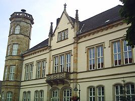


 Horn-Bad MeinbergLocation of the town of Horn-Bad Meinberg within Lippe district
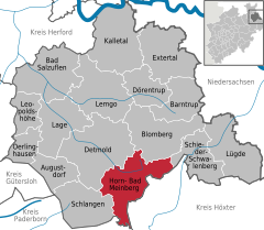

Coordinates 51°53′0″N 8°58′0″E / 51.883333°N 8.966667°ECoordinates: 51°53′0″N 8°58′0″E / 51.883333°N 8.966667°E Administration Country Germany State North Rhine-Westphalia Admin. region Detmold District Lippe Town subdivisions 17 Mayor Eberhard Block Basic statistics Area 90.16 km2 (34.81 sq mi) Elevation 285 m (935 ft) Population 17,704 (31 December 2010)[1] - Density 196 /km2 (509 /sq mi) Other information Time zone CET/CEST (UTC+1/+2) Licence plate LIP Postal code 32805 Area code 05234 Website www.horn-badmeinberg.de Horn-Bad Meinberg is a town in the Lippe district of North Rhine-Westphalia, Germany, with c. 18,300 inhabitants. It was formed in 1970 by merging various other towns that had grown together, including Bad Meinberg and Horn - the new entity's original name was Bad Meinberg-Horn, before taking its present name.
Horn-Bad Meinberg is the location of the Externsteine, a rock formation consisting of several tall, narrow columns.
References
- ^ "Amtliche Bevölkerungszahlen" (in German). Landesbetrieb Information und Technik NRW. 31 December 2010. http://www.it.nrw.de/statistik/a/daten/amtlichebevoelkerungszahlen/index.html.
External links
- Official website (English)
- Official website (German)
Augustdorf | Bad Salzuflen | Barntrup | Blomberg | Detmold | Dörentrup | Extertal | Horn-Bad Meinberg | Kalletal | Lage | Lemgo | Leopoldshöhe | Lügde | Oerlinghausen | Schieder-Schwalenberg | Schlangen Categories:
- Towns in North Rhine-Westphalia
- North Rhine-Westphalia geography stubs


Wikimedia Foundation. 2010.