- Mödlareuth
-
 The Mödlareuth wall today is part of an open-air museum
Mödlareuth is a German village situated partly in Bavaria and partly in Thuringia. The northern part was in East Germany and the southern part in West Germany. The Thuringian part of the village belongs to Gefell while the Bavarian part belongs to Töpen. It was called Little Berlin by the Americans[1] because a wall divided it, like the Berlin Wall divided Berlin. Now a museum shows the history of the village and gives information about the political system at that time.
Contents
History
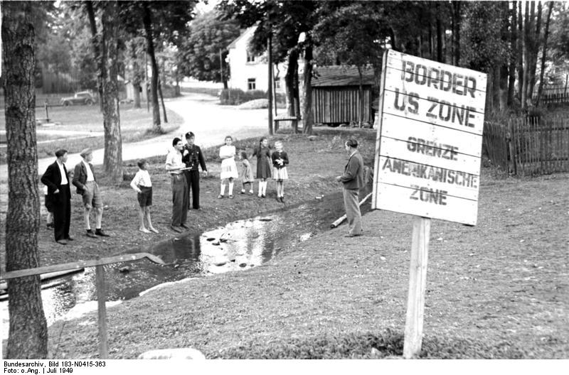
 The Mödlareuth border in 1949
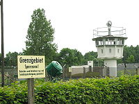
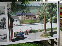 The Mödlareuth border in 1989
In 1810 (see Napoleonic Wars) the Tannbach stream (only around 30cms wide), which flows through Mödlareuth, became the new border between the Kingdom of Bavaria and the principality of Reuss Junior Line. For 140 years this border made little difference to the local populace. There was just one school and one restaurant.
In 1945, Thuringia (to which Reuß had belonged since 1920) became part of the Soviet occupation zone, while Bavaria went to the American occupation zone. When the constitutions of West Germany and East Germany were ratified in 1949, the village became divided by the border between two states. A pass was required to cross between the two parts of town.
In 1952, East Germany began to strengthen its western border. Residents of areas close to the border were forced to relocate, including some residents of Mödlareuth. In the case of Mödlareuth a wooden fence almost two metres high was built followed by more complex border fences. After the Berlin Wall was built in 1961, walls were built in other towns on the border as well. The wall separating the two halves of Mödlareuth was built in 1966. From that point on, the East German part of the village was strictly monitored day and night, while on the West German side the wall became a kind of tourist attraction. The Americans nicknamed the town Little Berlin.
In 1983, the then U.S. Vice President George H. W. Bush visited and exclaimed, "Ich bin ein Mödlareuther!", an allusion to John F. Kennedy's "Ich bin ein Berliner" statement.[1]
In December 1989 a pedestrian crossing was opened at Mödlareuth. On 17 June 1990, seven months after the Berlin Wall fell and four months before German reunification, the Mödlareuth Wall was knocked down using a bulldozer. A portion has been retained as a memorial and is part of the museum in the village.
Mödlareuth today
 Open-air museum
The Thuringian part of the village of Mödlareuth belongs to the town of Gefell, and the Bavarian part to the community of Töpen.
Since 1994, Mödlareuth has had an open-air museum about the border between East and West Germany. It includes a portion of the original wall as well as a rebuilt barrier typical of those on the border at the time.
Although there is free passage between the two parts of the village today, there are still many differences. They have different postal codes and telephone area codes; the residents vote separately and send their children to different schools.
References
External links
Coordinates: 50°24′52″N 11°52′59″E / 50.41444°N 11.88306°E
- http://www.moedlareuth.de/
- http://www.stadt-gefell.de/Museum/museum.htm
- http://www.youtube.com/watch?v=pVbVQYkVre0
- Photo Gallery by Enrico Martino
- This article incorporates information from the revision as of 2006-11-15 of the equivalent article on the German Wikipedia.
Categories:- Cold War
- Geography of Bavaria
- Geography of Thuringia
- Open air museums in Germany
- Inner German border
- Museums in Bavaria
- Museums in Thuringia
- Cold War museums in Germany


Wikimedia Foundation. 2010.