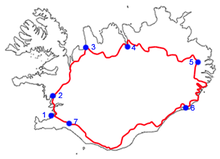
- Route 1 (Iceland)
-
See also: Route 1
Route 1 or the Ring Road (Icelandic: Þjóðvegur 1 or Hringvegur) is a main road in Iceland that runs around the island and connects all habitable parts of the country (the interior of the island being uninhabited). The total length of the road is 1,339 kilometres (832 mi).
For almost all its length, the road is two lanes wide with one lane in each direction. Where it passes through larger towns and cities it may be expanded to more lanes, as well as in the Hvalfjörður Tunnel. Most smaller bridges are single lane and made of wood and/or steel. The road is paved with asphalt for most of its length, but there are still stretches in the east part of the country with an unpaved gravel surface. The Iceland Road Administration, Vegagerðin oversees the maintenance and creation of national to small access roads in the country.
Traffic on the road varies a lot depending on location; in and near Reykjavík it is around 5,000–10,000 vehicles per day, but the stretches farthest away from larger towns see fewer than 100 vehicles per day on average.
The circle was finished in 1974 to celebrate the country's 1100 years of settlement[1] when the longest bridge in Iceland[2] over Skeiðará river in Southern Iceland was opened.
The Ring Road is popular with tourists since it covers most of the country and many interesting sights are not far from it. It has been an especially popular tour with Icelandic families on summer vacation, but in later years the route is becoming more popular with foreigners who like to either rent a car or bring their own on the ferry to Seyðisfjörður.
The south part of the Ring Road is sometimes destroyed by sudden massive floods caused by geothermal heat and volcano eruptions melting ice under Iceland's inland icecaps (usually Vatnajökull)
Contents
Driving on Route 1
Although paved, some portions of the road are still the original 1940s country roads, and contain hazards such as blind curves and blind hills, one lane bridges, and narrow passes. In winter, icy roads and sheer winds can make travel especially hazardous.
The maximum speed on most of the road is 90 kilometers per hour (56 miles per hour) where paved and 80 kilometers per hour over gravel. If driving on the road, it is advised to visit Iceland's official road bureau websites and weather station to lay out a route before starting.
List of cities and towns on Route 1
Travelling clockwise (initially northward) from Reykjavik, the following communities and settlements are located on Route 1.
- Reykjavik
- Mosfellsbær
- Grundarhverfi
- Borgarnes
- Bifröst
- Brú
- Blönduós
- Akureyri
- Reykjahlíð
- Egilsstaðir
- Breiðdalsvík
- Djúpivogur
- Höfn
- Kirkjubæjarklaustur
- Vík í Mýrdal (Vík)
- Skógar
- Hvolsvöllur
- Hella
- Selfoss
- Hveragerði
-
A typical stretch of Route 1, picture taken in Borgarfjörður
-
An icy stretch of Route 1 between Vík í Mýrdal and Höfn
-
Distance sign (Southbound) near Egilsstaðir
References
- ^ "Iceland: Milestones in Icelandic History". Iceland.vefur.is. http://iceland.vefur.is/Iceland_history/history.htm. Retrieved 2010-04-17.
- ^ http://www.vegagerdin.is/vefur2.nsf/Files/Vegakerfid_english/$file/ATTRJY5V.pdf
External links
Categories:- Roads in Iceland
- Populated places on Iceland's Route 1
- 1974 in Iceland
- Orbital roads
Wikimedia Foundation. 2010.


