- Rocky Hill - Glastonbury Ferry
Infobox Ferry route
name = The Rocky Hill - Glastonbury Ferry
nativename =
logosize =
imagesize =
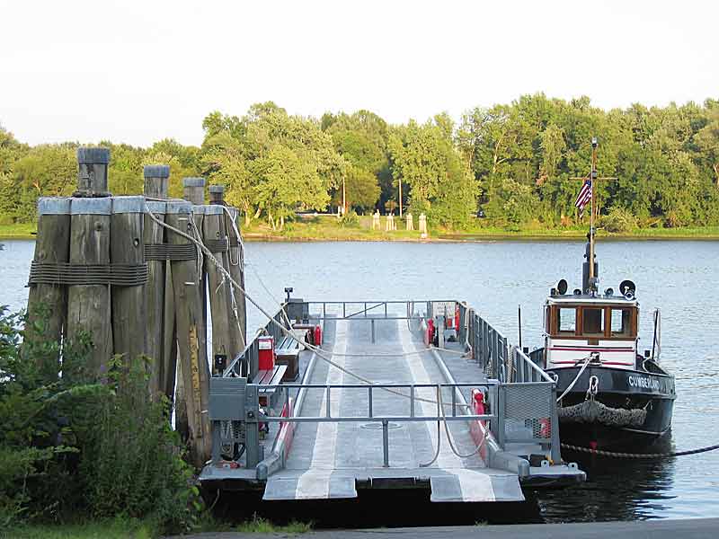
caption = The Hollister III (barge) and the Cumberland (tow boat)
crosses =Connecticut River
route =
line =
carries = pedestrians, bicycles, automobiles
locale = Rocky Hill to Glastonbury
coord|41.666363|N|72.629648|W to
coord|41.66565|N|72.626537|W
quays =
operator = Connecticut State Ferry Service
authority =Connecticut Department of Transportation (ConnDOT)
ferries = Cumberland tows Hollister III
ferrytype = towboat and barge
traveltime =
headway =
frequency = as needed
ridershipyear =
ridershipday = 400
vehiclesyear =
vehiclesday =
length =
opened = 1655
closed =
closes =
predecessor =
successor =The Rocky Hill - Glastonbury Ferry is a seasonal
ferry crossing theConnecticut River between the towns ofGlastonbury, Connecticut andRocky Hill, Connecticut and is part of Route 160. The river crossing has an annual average daily traffic of 400. [cite web | url = http://www.ct.gov/dot/LIB/dot/Documents/dpolicy/traflog/traflog.pdf#page=134 | title = 2005 Traffic Volumes State Maintained Highway Network (Traffic Log) | accessdate = 2007-01-11 | format = PDF | publisher = State of Connecticut Department of Transportation | pages = p.134]History
The ferry is the oldest continuously running ferry in the
United States ,cite web |url=http://www.ct.gov/dot/cwp/view.asp?a=1380&Q=259738&dotPNavCtr= |title=Rocky Hill - Glastonbury Ferry |accessdate=2007-06-24 |date=2005-10-20 |work=Connecticut Department of Transportation |publisher=State of Connecticut ] only shutting down in the winter when the river freezes over. [cite web |url=http://www.kurumi.com/roads/ct/ctx160.html |title=Routes 160-164 |accessdate=2007-06-24 |last=Oglesby |first=Scott |date=2006-10-22 |work=Connecticut Roads |publisher=Kurumi] Started in1655 it actually began before the foundation of the towns of Glastonbury and Rocky Hill, both towns then being part ofWethersfield, Connecticut at that time.Originally a raft that was poled across the Connecticut River, it was then for a while powered by a horse on a treadmill before being upgraded to a steamship in 1876. Today's ferry is a 3-car barge named the "Hollister III" towed by a diesel towboat named the "Cumberland".
Use
The ferry is the only river crossing accessible to pedestrians and bicyclists between Hartford and Middletown, preventing what would otherwise be a thirteen mile detour for them. [cite web |url=http://www.wethersfield.net/html/gov/ct/rhill/ferry/ferry-info.html |title=Rocky Hill Glastonbury Ferry Now 350 Years |accessdate=2007-06-24 |last=Sokolowski |first=Kenneth E. |year=2005 |work=Wethersfield.NET |publisher=Kenneth E. Sokolowski]
Operating between
May 1 andOctober 31 , the toll for cars is $3 and for cyclists & pedestrians is $1.ee also
*
List of crossings of the Connecticut River
*Chester - Hadlyme Ferry , the second oldest continuously running ferry in the U.S. operating just 25 miles downstream.References
External links
* [http://www.ct.gov/dot/cwp/view.asp?a=1380&Q=259738&dotPNavCtr= The Ferry's page on the Conn-DOT's website]
Crossings navbox
structure = Crossings
place =Connecticut River
bridge = Rocky Hill - Glastonbury Ferry
bridge signs =upstream =
William H. Putnam Memorial Bridge
upstream signs =
downstream =Arrigoni Bridge
downstream signs =
Wikimedia Foundation. 2010.
