North Umpqua Trail

North Umpqua Trail
North Umpqua Trail
Dreadandterrorwater.jpg
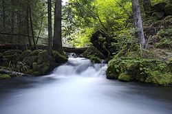
View of a small waterfall on the Dread and Terror Section of the North Umpqua Trail
Length 79 mi; 127 km
Location Douglas County, Oregon, USA
Trailheads Swiftwater
Wright Creek
Mott
Panther
Calf
Marsters
Soda Springs
Toketee Lake
Hot Springs
White Mule
Kelsay Valley
Digit Point
Use Hiking
Horse riding
Mountain Biking
Elevation Change 4,200 ft (1280 m)
Highest point Maidu Lake (6,000 ft, 1828 m)
Lowest point Swiftwater Trailhead
Trail difficulty Easy to Difficult
Months Lower Sections Open Year Round
Upper Sections Late April to Late September
Sights North Umpqua River
Cascade Range
Hazards Severe Weather
Dehydration
Wildlife
Poison Oak

The North Umpqua Trail is a multi-use trail open for hiking, mountain biking and horse-back riding that follows the North Umpqua River in Southern Oregon, United States. The trail is about 79 miles (127 km) long. It is broken up into 11 sections, ranging from 3.5 to 15.7 miles (25.3 km) in length. The trail ranges in elevation from 800 feet (240 m) to about 6,000 feet (1,800 m).

Route

The North Umpqua Trail follows the North Umpqua River as it winds west out of the Cascades and towards the city of Roseburg, Oregon. The trail is inside the Umpqua National Forest and closely follows the river most for most of its length. Since it is in a national forest, the trail almost completely avoids all human structures, except at one of the trail heads.

External links


Wikimedia Foundation. 2010.

Игры ⚽ Поможем написать реферат

Look at other dictionaries:

  • North Umpqua River — Coordinates: 43°16′05″N 123°26′45″W / 43.2681707°N 123.4459121°W / 43.2681707; 123.4459121 …   Wikipedia

  • Umpqua River — Daten Gewässerkennzahl …   Deutsch Wikipedia

  • Umpqua National Forest — Infobox protected area | name = Umpqua National Forest iucn category = V caption = locator x = 18 locator y = 39 location = Oregon, USA nearest city = Roseburg, Oregon lat degrees = 43 lat minutes = 13 lat seconds = 21 lat direction = N long… …   Wikipedia

  • North Fork Umatilla Wilderness — IUCN Category Ib (Wilderness Area) View to the west from the Coyote Ridge trail. The North Fork of the Um …   Wikipedia

  • North Bend, Oregon —   City   North Bend from above, looking toward the Pacific Ocean …   Wikipedia

  • South Umpqua River — The South Umpqua River is a tributary of the Umpqua River, approximately convert|95|mi|km|0 long, in southwestern Oregon in the United States. It drains part of the Cascade Range east of Roseburg. The river passes through a remote canyon in its… …   Wikipedia

  • OC&E Woods Line State Trail — OC E Trail through Klamath Falls at Wiard Park …   Wikipedia

  • Siskiyou Trail — The Siskiyou Trail stretched from California s Central Valley to Oregon s Willamette Valley; modern day Interstate 5 follows this pioneer path. Originally based on existing Native American foot trails winding their way through river valleys, the… …   Wikipedia

  • Oregon Coast Trail — The Oregon Coast Trail at Floras Lake, looking north to the BLM s New River Area of Critical Environmental Concern (ACEC) Length 425 mi (684 km) Location Pacific Ocean coast of Oregon, USA …   Wikipedia

  • Pacific Crest Trail — Infobox Hiking trail Name=Pacific Crest Trail Photo=OldSnowy 15A.jpg Caption=View of Goat Rocks Wilderness along Pacific Crest Trail Location=Western United States Length=2,650 mi; 4,240 km Start/End Points=Campo, California Manning Park, British …   Wikipedia

Share the article and excerpts

Direct link
Do a right-click on the link above
and select “Copy Link”