- Dunford Bridge railway station
-
Dunford Bridge 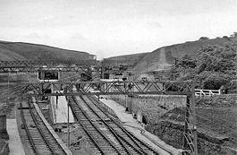
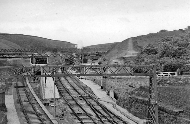
Dunford Bridge railway station in 1954 Location Place Dunford Bridge Area Barnsley Coordinates 53°31′02″N 1°45′42″W / 53.51714°N 1.76168°WCoordinates: 53°31′02″N 1°45′42″W / 53.51714°N 1.76168°W Grid reference SE158023 Operations Original company Sheffield, Ashton-under-Lyne and Manchester Railway Pre-grouping Great Central Railway Post-grouping London and North Eastern Railway Platforms 2 History 14 July 1845 opened 1954 station moved to new alignment 5 January 1970 closed Disused railway stations in the United Kingdom Closed railway stations in Britain
A B C D–F G H–J K–L M–O P–R S T–V W–Z The station in 1950
Dunford Bridge railway station was a railway station on the Sheffield, Ashton-under-Lyne and Manchester Railway situated immediately east of the Woodhead Tunnel, 5 miles (8.0 km) west of Penistone, within the Metropolitan Borough of Barnsley, South Yorkshire, England.
History
When the line over Woodhead was opened in 1845 the tunnels were incomplete and a stagecoach service operated from here over the hills to the station at Woodhead. Because the turning space at Hazlehead Bridge was inadequate services the stagecoach links in the Huddersfield direction via Holmfirth were also operated from here.
The station was opened on 14 July 1845[1] and consisted of two flanking platforms, the main, stone built structure, with booking office and staff accommodation was on the Manchester-bound (Down) platform, whilst the Sheffield-bound platform (Up) had a large water tower alongside a stone built waiting shelter. Immediately east of the station was access to sidings which served stone quarries.
The area was controlled from a signal box positioned near the road bridge at the west end of the station but this was replaced by a larger cabin, of the late Manchester, Sheffield and Lincolnshire Railway design, immediately east of the station buildings, on the up platform.
This station was replaced by a modern structure in 1954 when the line was electrified. Still with flanking platforms but now realigned with the line through the "new" Woodhead Tunnel the main building was still on the down platform with a simple waiting shelter on the up.
The station was closed with the passenger services on the line on 5 January 1970.
References
- Dow, George. "Great Central Volume 1" (The Progenitors 1813 - 1965), Locomotive Publishing Company, London. 1965.
- ^ "Dunford Bridge "Disused Stations". Subterranea Britannica. http://www.subbrit.org.uk/sb-sites/stations/d/dunford_bridge.".
External links
Preceding station Disused railways Following station Woodhead SAMR
Woodhead LineHazlehead Bridge Categories:- Disused railway stations in Barnsley
- Former Great Central Railway stations
- Railway stations opened in 1845
- Railway stations closed in 1970
- Woodhead Line
- Yorkshire and the Humber railway station stubs
Wikimedia Foundation. 2010.