- Cap-Rouge, Quebec City
-
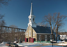 Old Village's Church
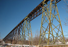 The Tracel Bridge
Cap-Rouge (English: Red Cape) is located in central Quebec, Canada on the Saint Lawrence River within Quebec City. Originally a town on its own, Cap-Rouge was incorporated within Québec on January 1, 2002 and is now part of the Borough Sainte-Foy–Sillery–Cap-Rouge.
History
Jacques Cartier attempted to create the first permanent European settlement in North America at the location of present-day Cap-Rouge in 1541. Named Charlesbourg-Royal, the settlement of 400 people did survive its first winter due to harsh weather and attacks from neighbouring Iroquoians of Stadacona and other villages and was abandoned in June 1542. In August 2006, Quebec Premier Jean Charest and Canadian archaeologists under Yves Chretien announced the discovery of this long-lost settlement. Yves Chretien identified its location from fragments of a decorated c.1540-1550 Italian style ceramic plate and six wood timber samples which were dated to the mid-16th century by a United States laboratory.[1]
Re-occupied with the French colonisation effort of the 17th century, the area was used for agricultural activities until the 1960s when residential developments took over and transformed the area into a residential suburb of Québec City.
Attractions
Apart from a long history, the main attraction of Cap-Rouge is a rail-only trestle steel bridge named "Tracel" built in 1907-1908. Gustave Eiffel, from whom the Eiffel Tower takes its name, participated in the project. It was constructed under the authority of the National Transcontinental as part of the Winnipeg-Moncton trunk while the Winnipeg-Prince Rupert section was built by the Grand Trunk Pacific. The steel bridge spans 3,335 feet at an average of 172 feet above ground and is still in use today.
See also
Quebec City Boroughs La Cité–Limoilou • Les Rivières • Sainte-Foy–Sillery–Cap-Rouge • Charlesbourg • Beauport • La Haute-Saint-Charles • Laurentien (defunct)
Districts Vieux-Québec–Cap-Blanc–colline Parlementaire (Old Quebec, Parliament Hill, Petit Champlain) • Saint-Jean-Baptiste • Saint-Roch • MaizeretsAgglomeration See also: List of articles about Quebec City • History of Quebec City • Quebec Metropolitan Community • Municipal reorganization in Quebec
1) Within agglomeration boundaries but administratively not part of itCoordinates: 46°45′N 71°21′W / 46.75°N 71.35°W
Categories:- Neighbourhoods in Quebec City
- Former municipalities in Quebec
- Quebec City stubs


Wikimedia Foundation. 2010.