- L'Anse Indian Reservation
-
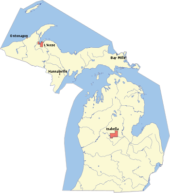
The L'Anse Indian Reservation is the land base of the Keweenaw Bay Indian Community of the Lake Superior Bands of Chippewa Indians (successor apparent of the L’Anse and Ontonagon Bands). It is located primarily in two non-contiguous sections on either side of the Keweenaw Bay in Baraga County in the Upper Peninsula of the U.S. state of Michigan. The largest section lies in northern L'Anse Township and western Arvon Township on the east side of Keweenaw Bay, while the smaller section lies in northern Baraga Township on the west side of Keweenaw Bay. There is also a much smaller (43.07 acre) part of the reservation in northern Chocolay Township in northeastern Marquette County. The total land area of the reservation is 92.132 sq mi (238.622 km²) and there were 3,672 persons residing on its territory as of the 2000 census, of whom more than 69 percent were white people and only 24.4 percent of solely Native American heritage. Most of the village of Baraga and part of the village of L'Anse are on reservation land.
In 1999, tribal enrollment was 3,159 according to the Bureau of Indian Affairs 1999 Labor Force Report.
The L’Anse Reservation is both the oldest and largest reservation in Michigan. It was established under the Chippewa Treaty of 1854. The United States Supreme Court has interpreted this treaty as creating permanent homelands for the Chippewa (Ojibwa Anishnaabeg) signatories to the treaty. The Treaty of 1842, which ceded lands to the federal government, was one of the largest land cession agreements ever made between the U.S. federal government and Indian tribes. It includes provisions and stipulations that the Chippewa retain their rights to fish, hunt and gather on these ceded lands.
The L’Anse Reservation consists of 54,000 acres (220 km²) with approximately 14,000 acres (57 km²) owned by the tribal community. Two thirds of the land is held in tribal common ownership and the remaining third is owned by Indians in fee, restricted fee, or allotted lands status. The entire reservation encompasses nearly one third of the area of Baraga County.
References
- L'Anse Reservation and Off-Reservation Trust Land, Michigan United States Census Bureau
External links
- Background from the Inter-Tribal Council of Michigan
- Keweenaw Bay Indian Community Online
- Constitution and By-Laws of the Keweenaw Bay Indian Community
Coordinates: 46°46′52″N 88°24′08″W / 46.78111°N 88.40222°W
Lake Superior Chippewa Full political Successors Bad River • Bois Forte • Fond du Lac • Grand Portage • Keweenaw Bay • Lac Courte Oreilles • Lac du Flambeau • Lac Vieux Desert • Red Cliff • Sokaogon • St. CroixMinor political Successors Categories:- Geography of Baraga County, Michigan
- Geography of Marquette County, Michigan
- Ojibwe
- Anishinaabe reservations and tribal-areas in the United States
- American Indian reservations in Michigan
- Native American tribes in Michigan
Wikimedia Foundation. 2010.

